
Any Question? Email Us
info@nepalhimalayastrekking.comTalk To An Expert ( Prakash Lamsal )
Any Question? Email Us
info@nepalhimalayastrekking.comTalk To An Expert ( Prakash Lamsal )
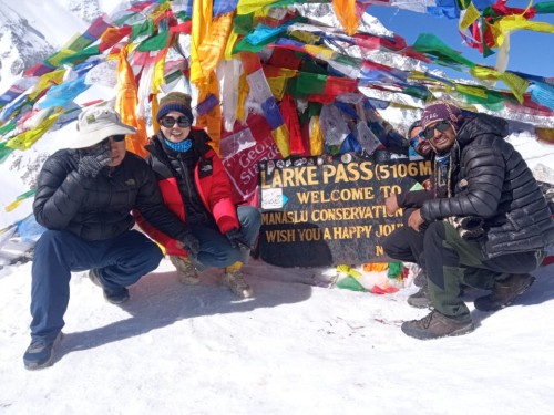
The Manaslu Circuit Trek (2026/27) is a 14-day walk around the world's eighth-highest mountain, Manaslu (8,163 m), through one of Nepal's least crowded conservation areas. You follow the Budhi Gandaki River past dense forests and swaying suspension bridges, pass Gurung and Tibetan-influenced villages, and cross Larke La Pass (5,160 m) with views of Manaslu, Himalchuli, Naike Peak, Ganesh Himal and Annapurna II. A rest day at Samagaon gives your body time to adjust before the climb to the pass.
Because the route runs through a restricted area, you need special permits and a licensed guide, and most trekkers also hire a porter. We arrange all of it, and the itinerary can be adjusted to suit your pace and interests. Solo trekkers are welcome: since March 2026, a single traveller can obtain the permit without a partner, as long as they walk with a licensed guide. This is a trek for people who want scenery and culture in equal measure.
| Duration | 14 days Kathmandu to Kathmandu (12–16 days possible) |
| Trek distance | About 177 km (110 miles) |
| Start/end | Drive to Machha Khola (930 m) / trek ends at Dharapani, then drive via Besisahar to Kathmandu |
| Highest point | Larke La Pass, 5,160 m (16,929 ft) |
| Highest sleeping altitude | Dharamsala (Larkya Phedi), 4,460 m |
| Lowest point | Machha Khola, 930 m |
| Difficulty | Moderate to strenuous (challenging); 5–8 hours' walking a day, longer on pass day |
| Best seasons | Spring (March–May) and autumn (mid-September–November; early December possible if the pass is clear) |
| Accommodation | Teahouses and lodges (standard, basic at altitude) |
| Transport | Private jeep or public bus |
| Group size | From 1 traveller (with a licensed guide); groups up to 25 |
| Trip type | Trekking/hiking / walking / restricted-area trek |
| Permits | Manaslu Restricted Area Permit (RAP), Manaslu Conservation Area Permit (MCAP), Annapurna Conservation Area Permit (ACAP) and the Chumnubri Rural Municipality entry fee |
| Price | From US$1,290 per person (2–5 travellers); US$1,390 for one traveller |
Regular Service Package: US$1,290 per person (2–5 travellers)
| Group size | Price per person |
|---|---|
| 1 traveller | US$1,390 |
| 2–4 travellers | US$1,290 |
| 5–7 travellers | US$1,225 |
| 8–12 travellers | US$1,190 |
| 13+ travellers | US$1,160 |
The Manaslu Circuit Trek takes you around Mount Manaslu (8,163 m), the eighth-highest mountain in the world. Over 12–14 days the trail winds through the remote Manaslu region, crosses Larke La Pass (5,160 m) and passes villages where Tibetan Buddhist culture is still part of daily life. (Larke La is also quoted at 5,106 m and up to 5,213 m by different sources, depending on where and how the pass is measured.)
The route opened to foreign trekkers in 1991 and has become one of Nepal's finest off-the-beaten-path treks. Compared with the Everest and Annapurna regions it has quieter trails, big mountain scenery, more varied landscapes and a way of life that has changed little in generations. Roughly 12,000 trekkers walked the circuit in the 2024 season, against about 50,000 on the Everest Base Camp trek.
The name Manaslu comes from the Sanskrit Manasa, meaning "soul" or "intellect", a reflection of the mountain's spiritual importance to local people. On the way, you pass from subtropical forest and deep river gorge to alpine meadow, glacier and high pass, with views of Manaslu, Himalchuli, Ganesh Himal, Himlung Himal and the Annapurna range.
It is more than a mountain walk. The trail follows old trading routes through the isolated Nubri Valley, where monasteries, prayer wheels, mani walls and stone villages give a view of a way of life that has endured for centuries. If you want fewer crowds, big scenery and real cultural contact, the Manaslu Circuit is one of Nepal's most complete treks.
| Trek duration | 14 days (12–16 days possible) |
| Minimum elevation | 930 m (Machha Khola) |
| Maximum elevation | 5,160 m (Larke La Pass) |
| Highest sleeping altitude | 4,460 m (Dharamsala) |
| Difficulty | Moderate to strenuous |
| Best seasons | March–May (spring); mid-September–November (autumn) |
| Accommodation | Tea houses and lodges (standard) |
| Distance | About 177 km (110 miles) |
| Daily walking | 5–8 hours (8–10 hours on pass day) |
| Starting point | Machha Khola (after a drive from Kathmandu) |
| Ending point | Dharapani (followed by a drive to Kathmandu via Besisahar) |
| Permits | Manaslu Restricted Area Permit (RAP), Manaslu Conservation Area Permit (MCAP), Annapurna Conservation Area Permit (ACAP), Chumnubri Rural Municipality entry fee |
| Transportation | Private jeep or public bus |
| Group size | 1–25 (solo travellers welcome with a licensed guide) |
The Manaslu Circuit combines big mountain scenery, Tibetan Buddhist culture and high-altitude trekking in a single journey. Read more in our Manaslu trekking facts guide.
Manaslu is one of Nepal's most authentic and least commercialised treks. Everest Base Camp and the Annapurna Circuit draw tens of thousands of trekkers a year; Manaslu offers a quieter, more immersive journey through remote landscapes and culturally rich villages.
The trek balances adventure and authenticity. The route circles Manaslu, crosses Larke La and passes villages where Tibetan Buddhist traditions shape everyday life: ancient monasteries, spinning prayer wheels, stone houses and centuries-old trading routes.
The restricted-area status helps protect the region's natural beauty and culture. Because you need special permits and a licensed guide, visitor numbers stay low and the trails stay peaceful.
Compared with the Everest region, the circuit is usually more affordable because there are no domestic flights. Compared with the Annapurna Circuit, it is more remote and less developed, but you still sleep in tea houses all the way. Whether you are an experienced trekker looking for a new challenge or want a quieter alternative to Nepal's busiest treks, Manaslu delivers.
The 14-day Manaslu Circuit takes you through remote villages, forests, river valleys and high passes. The scenery, culture and mountain views change almost every day.
You drive from Kathmandu to Machha Khola, then walk up the Budhi Gandaki River through terraced fields, forest, waterfalls and suspension bridges to Jagat, the official entry point to the restricted Manaslu region.
From Jagat to Namrung, Lho and Samagaon, you pass stone villages shaped by Tibetan Buddhism. Monasteries, prayer flags, mani walls and chortens line the trail, and the tea houses are a chance to meet local families.
A rest day in Samagaon lets your body adjust before Larke La. You can visit Birendra Lake, hike towards Manaslu Base Camp or explore Pungyen Gompa, with Manaslu and its neighbours in view.
The highlight is Larke La Pass (5,160 m). After an early-morning climb, you see Manaslu, Himlung Himal, Cheo Himal and Annapurna II, then descend to the alpine valley of Bimthang.
Past Bimthang, the trail runs through alpine meadows, pine forest and glacial streams to Dharapani, where the Manaslu Circuit meets the Annapurna Circuit. From there you drive via Besisahar back to Kathmandu.
The Manaslu Circuit is open but rougher than usual. A flash flood on 6 September 2026 washed away bridges near Namrung, and travel was briefly suspended. The Gorkha District Administration Office has since lifted the restriction after building temporary wooden crossings. Permanent bridges are still to come.
Essential for Larkya La: warm layers, gloves, beanie, sunglasses, sunscreen, trekking poles, water, snacks, and a good sleeping bag.
We meet you at the airport and transfer you to your hotel. Your permits (Manaslu Restricted Area Permit, ACAP and MCAP) are prepared and we finalise trek logistics and gear. Enjoy a cultural evening in the city.
Elevation: 930m (3,051ft)
Distance: ~160 km (99 miles)
Driving Hours: 7–8 hours
Description: Drive via Dhading Besi and Arughat to reach Machha Khola. Enjoy scenic countryside views along the Budi Gandaki River.
Elevation Gain: +410m
Distance: 22 km (13.7 miles)
Walking Hours: 6–7 hours
Description: Pass through villages like Khorlabesi and Tatopani (hot springs). Cross suspension bridges and enjoy beautiful river views. Register permits at Jagat.
Elevation Gain: +520m
Distance: 19 km (11.8 miles)
Walking Hours: 6–7 hours
Description: Walk past Salleri, Sirdibas, and Philim. The trail narrows with steep ascents and lush greenery.
Elevation Gain: +770m
Distance: 20 km (12.4 miles)
Walking Hours: 6–7 hours
Description: Enjoy views of Shringi Himal and trek through alpine terrain. Cross several mani walls and Buddhist settlements.
Elevation Gain: +900m
Distance: 17 km (10.5 miles)
Walking Hours: 6–7 hours
Description: Pass through Lho and Sho villages with stunning views of Manaslu (8,163m). Experience Tibetan culture as you approach Samagaon.
Elevation: 3,530m (11,581ft)
Distance: Optional hikes (~5 km/3 miles for short hikes)
Walking Hours: 3–5 hours (optional)
Description: Rest and explore nearby sites such as the Pungyen Monastery or Birendra Lake. Acclimatize for the high altitudes ahead.
Elevation Gain: +330m
Distance: 16 km (9.9 miles)
Walking Hours: 4–5 hours
Description: A short, pleasant hike along the river valley. Enjoy views of glaciers and Tibetan-influenced villages.
Elevation Gain: +600m
Distance: 12 km (7.5 mi