
Any Question? Email Us
info@nepalhimalayastrekking.comTalk To An Expert ( Prakash Lamsal )
Any Question? Email Us
info@nepalhimalayastrekking.comTalk To An Expert ( Prakash Lamsal )
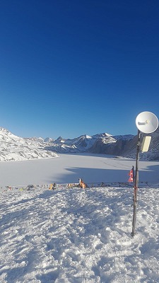
The Tilicho Lake Trek is a 14-day high-altitude trek in Nepal's Annapurna region, combining the classic Annapurna trail with a side route to Tilicho Lake at 4,919 meters (16,138 ft) and the crossing of Thorong La Pass at 5,416 meters (17,769 ft). The trek begins in Kathmandu and follows the Marsyangdi Valley through Dharapani, Chame, Pisang and Manang before leaving the main Annapurna Circuit route toward Khangsar and Tilicho Base Camp. After visiting Tilicho Lake, the trail reconnects with the Annapurna Circuit around Yak Kharka and continues to Thorong Phedi and Muktinath.
The route changes considerably as you gain altitude. The lower Marsyangdi Valley is surrounded by forests, cultivated hillsides and river valleys, while the landscape around Manang becomes drier and more open. Beyond Khangsar, the trail enters the high and rugged Tilicho Valley, where steep slopes, loose rock and limited vegetation become part of the walking environment. The climb to Tilicho Lake is one of the most demanding sections of the trek, followed by the high-altitude approach to Thorong La.
Our 14-day itinerary includes an acclimatization day in Manang before entering the higher sections. It also uses Shree Kharka after the Tilicho Lake excursion, followed by Yak Kharka and Thorong Phedi, giving you a gradual return to the main Annapurna Circuit before the Thorong La crossing. The route from Shree Kharka through the Old Khangsar area toward Yak Kharka provides the connection back to the main circuit without requiring you to return all the way to Manang.
The Tilicho route therefore combines a major section of the Annapurna Circuit Trek with the Tilicho Lake detour. You leave the main circuit around Manang and Khangsar, reach Tilicho Lake, then reconnect with the main circuit around Yak Kharka before continuing toward Thorong La.
The trek finishes with the descent from Thorong La to Muktinath, followed by travel toward Jomsom and the planned Jomsom–Pokhara flight. Because mountain flights depend on weather and operating conditions, the final transportation schedule remains subject to the conditions on the day.
| Trek Fact | Details |
|---|---|
| Trek Duration | 14 Days |
| Trek Region | Annapurna Region |
| Maximum Elevation | 5,416 m / 17,769 ft |
| Major Lake | Tilicho Lake, 4,919 m / 16,138 ft |
| Highest Pass | Thorong La, 5,416 m / 17,769 ft |
| Difficulty | Challenging |
| Starting Point | Kathmandu |
| Ending Point | Kathmandu |
| Accommodation | Hotel, teahouse and mountain lodge |
| Best Seasons | March–May and September–November |
| Permits | ACAP and TIMS |
| Group Size | 1–25 people |
| Guide | Licensed trekking guide |
| Porter | Included according to the confirmed package |
| Main Valleys | Marsyangdi Valley and Tilicho Valley |
| Major Settlements | Manang, Khangsar, Shree Kharka, Yak Kharka, Muktinath and Jomsom |
Kathmandu → Besisahar → Dharapani → Chame → Pisang → Manang → Khangsar → Tilicho Base Camp → Tilicho Lake → Shree Kharka → Yak Kharka → Thorong Phedi → Thorong La → Muktinath → Jomsom → Pokhara → Kathmandu
The route first follows the Marsyangdi Valley toward Manang before turning toward Tilicho Lake. The Tilicho route branches from the main Annapurna Circuit around Manang and Khangsar, reaches Tilicho Lake through the Tilicho Valley, and then reconnects with the main circuit around Yak Kharka. From there, the trail continues through Ledar to Thorong Phedi before crossing Thorong La and descending into the Mustang side of the Annapurna region.
The Tilicho Lake Trek costs US$1,350 per person for a group of 2–5 trekkers. We have structured the price according to group size because guide, porter, transportation and operational costs can be shared more efficiently as the group becomes larger.
| Group Size | Price Per Person |
|---|---|
| 1 person | US$1,450 |
| 2–5 people | US$1,350 |
| 6–10 people | US$1,290 |
| 11–15 people | US$1,240 |
| 16–25 people | US$1,190 |
The package price accounts for the additional logistics of the Tilicho detour, high-altitude trekking support and the planned Jomsom–Pokhara flight. Transportation and flight arrangements can still be affected by weather, road conditions and operational changes, so the exact services included in your booking will be confirmed before departure.
The Tilicho Lake Trek falls within the Annapurna Conservation Area and requires the Annapurna Conservation Area Permit (ACAP) and TIMS Card. The current Nepal Tourism Board protected-area fee table lists the ACAP entry fee for foreign visitors at NPR 3,000 per person, while the Nepal Tourism Board's current TIMS information lists NPR 2,000 for non-SAARC applicants.
| Permit | Current Fee |
|---|---|
| Annapurna Conservation Area Permit | NPR 3,000 |
| TIMS Card, non-SAARC | NPR 2,000 |
| Total | NPR 5,000 |
The route does not require a separate Tilicho Lake permit. We arrange the required trekking documentation as part of the organized trek.
We recommend beginning your physical preparation around 6–8 weeks before the trek. Regular uphill walking, stair training, hiking and aerobic exercise are useful because the trek involves repeated climbs and descents rather than simply walking on level trails. Longer weekend hikes with a daypack are particularly helpful for getting used to several hours of continuous walking.
Your preparation should also include breaking in your trekking boots before departure and practicing with the equipment you plan to use. At high altitude, cold temperatures, strong sunlight and wind can make a moderate walking day feel considerably harder, so appropriate clothing and hydration are as important as physical fitness.
Most importantly, prepare yourself for a gradual pace. You do not need to race toward Tilicho Lake or Thorong La. Our guides focus on steady walking, appropriate rest and altitude awareness throughout the higher sections.
Our 14-day Tilicho Lake Trek can be customized according to your travel dates, group size, fitness level, available time and preferred pace. If you want more time for acclimatization, we can add an extra night in Manang or adjust the walking schedule around Tilicho Lake. Private groups can also request changes to transportation, accommodation and walking distances to make the journey more comfortable and practical.
For travelers looking for a longer Himalayan experience, the trek can be combined with Nar Phu Valley or extended toward Upper Mustang. You can also add Pokhara sightseeing after completing the trek or extend your stay in Kathmandu for Kathmandu Valley sightseeing. If you prefer to reduce overland travel, we can arrange a Pokhara–Kathmandu flight as part of your customized itinerary.
For a more extensive Mustang experience, you can continue from Jomsom to Upper Mustang and then travel to Pokhara, with transportation and flight arrangements planned according to the season and operating conditions. A helicopter flight from the Jomsom/Upper Mustang area to Pokhara can also be arranged as a customized option, subject to weather, availability and operational conditions. Whether you are traveling with family, friends or a larger private group, we can discuss the route and adjust the itinerary before confirming your booking.
At Nepal Himalayas Trekking, we organize the Tilicho Lake Trek around the actual requirements of a high-altitude route. Our licensed guides accompany you through the mountain sections, monitor your pace and help you make practical decisions when altitude, weather or trail conditions affect the planned itinerary.
The Tilicho section requires particular attention because the trail becomes more exposed after Khangsar, accommodation becomes simpler at higher elevations and the climb to Tilicho Lake is followed by a demanding descent. We prepare you for these changes before reaching the higher sections rather than treating the trek as a standard low-altitude walking itinerary.
Our goal is to provide clear information before departure, practical support throughout the trek and a properly organized return from the mountains. If you are planning the Tilicho Lake Trek and want to discuss the route, dates, group size or a customized itinerary, contact Nepal Himalayas Trekking and our team can help you plan the trek according to your requirements.
If you are planning to visit Tilicho Lake and cross Thorong La Pass in the same trek, contact Nepal Himalayas Trekking with your preferred travel dates and group size. We can confirm the package price, transportation, accommodation, guide and porter arrangements, permits and Jomsom–Pokhara flight arrangements before your departure. You can also make an inquiry if you need to adjust the itinerary or combine the trek with other destinations in the Annapurna region.
The 14-day Tilicho Lake Trek brings together the Marsyangdi Valley, Manang, Khangsar, Tilicho Lake at 4,919 meters, Shree Kharka, Yak Kharka, Thorong Phedi, Thorong La at 5,416 meters, Muktinath and Jomsom in one continuous Annapurna adventure. If you are looking for other trekking options, you can also explore our Annapurna trekking packages and choose an itinerary that better matches your available time and interests.
Ready to plan your Tilicho Lake Trek? Contact our team with your preferred dates and group size, or visit our Make an Inquiry section to start planning your trip with Nepal Himalayas Trekking.
Your Tilicho Lake Trek begins with your arrival in Kathmandu, where our team will meet you at the airport and transfer you to your hotel. After checking in, you can rest or explore the surrounding area depending on your arrival time. We also use the first day to review the trekking route, check your equipment and make sure you are prepared for the gradual increase in altitude during the journey. Since the trek eventually reaches 5,416 meters, this preparation is important before leaving Kathmandu.
Overnight: Hotel in Kathmandu
Elevation: 1,400 m
Activity: Arrival and trek preparation
We leave Kathmandu by road and travel west toward Besisahar, passing through the changing landscapes of central Nepal. The route gradually leaves the Kathmandu Valley and follows river valleys, terraced hillsides and mountain settlements toward the Annapurna region. After Besisahar, the road continues deeper into the Marsyangdi Valley toward Dharapani. The journey is long, but it introduces you to the geography of the Annapurna region before the main walking section begins. Dharapani is an important settlement on the Annapurna Circuit and provides the starting point for the higher mountain trail.
Overnight: Teahouse/lodge in Dharapani
Elevation: 1,860 m
Activity: Drive
From Dharapani, the route continues through the upper Marsyangdi Valley toward Chame. The trail and road corridor pass through pine and fir forests, small mountain settlements and steep valley walls as the elevation gradually increases. The Marsyangdi River remains an important feature of the route, while views toward the surrounding peaks become more prominent as you approach Chame. The vegetation is still relatively dense at this stage, but the landscape is already beginning to change as the route moves farther into the mountain interior.
Overnight: Teahouse/lodge in Chame
Elevation: 2,650 m
Trekking: Approximately 5–6 hours
Leaving Chame, the trail follows the Marsyangdi Valley through pine forests and increasingly rugged terrain. You pass through Brathang and continue toward the settlements around Pisang, where the valley opens and the mountains become more dominant. The route gradually enters the drier landscape characteristic of the upper Marsyangdi Valley, with less dense vegetation and broader views of the surrounding peaks. Pisang is an important transition point before the route climbs toward Manang, and you can already feel the change from the greener lower valley to the drier high-mountain environment.
Overnight: Teahouse/lodge in Pisang
Elevation: 3,250 m
Trekking: Approximately 4–6 hours
Today we continue from Pisang toward Manang, following the upper Marsyangdi Valley. Depending on trail conditions and the route selected by our guide, the trail can take the higher route around the villages above the valley, providing broader views before descending toward Manang. The scenery becomes noticeably drier as you move farther into the rain-shadow area north of the Annapurna range. The surrounding peaks, traditional villages and wide mountain valley make this one of the most scenic stages of the approach to Manang. Once you reach Manang, you have time to settle into the lodge and prepare for the higher-altitude Tilicho section.
Overnight: Teahouse/lodge in Manang
Elevation: 3,519 m
Trekking: Approximately 5–7 hours
We spend a full day in Manang to allow your body to adjust to the altitude before the route climbs above 4,000 meters. The day is not intended to be completely inactive. A short acclimatization hike around Manang and its surrounding viewpoints provides some additional elevation gain before returning to the village to rest. If conditions and your fitness allow, an optional longer hike can also be discussed with your guide, but there is no need to undertake a demanding side trip simply for the sake of gaining altitude. You can also use the day to organize your daypack, refill water, check your warm clothing and prepare for the colder conditions around Tilicho Base Camp.
The acclimatization stop is particularly important because the next stages take you rapidly into the high-altitude zone. Our guide also uses this day to assess how everyone is responding to the elevation before the group moves toward Khangsar and Tilicho Base Camp.
Overnight: Teahouse/lodge in Manang
Elevation: 3,519 m
Activity: Acclimatization hike and rest
After acclimatizing in Manang, we leave the main village and turn toward Khangsar, entering the side valley that leads to Tilicho Lake. The route follows the Khangsar Khola through increasingly rugged terrain, with the main Annapurna Circuit gradually disappearing behind you. Khangsar is an old mountain settlement surrounded by steep slopes and high peaks, and it provides an important transition between the main circuit and the remote Tilicho Valley. From here, the trail becomes more exposed and the elevation rises quickly, so we keep the pace controlled and allow enough time for your body to adjust.
Overnight: Teahouse/lodge in Khangsar
Elevation: 3,734 m
Trekking: Approximately 4–5 hours
Today we continue deeper into the Tilicho Valley. The route climbs from Khangsar toward Shree Kharka and then follows the high trail toward Tilicho Base Camp. The section between Shree Kharka and Tilicho Base Camp is one of the more exposed parts of the route, with narrow sections, loose scree and steep mountain slopes. Rockfall and unstable trail surfaces can occur, particularly after periods of rain or changing mountain conditions, so careful footing and attention to the guide are important.
The landscape becomes increasingly barren as the trail leaves the lower vegetation behind. Although the walking distance is not especially long, the combination of altitude, exposure and uneven terrain makes this a demanding stage. We maintain a steady pace and allow extra time where the trail requires careful movement rather than rushing to Base Camp. The final approach to Tilicho Base Camp brings you into a high mountain setting surrounded by steep slopes and the peaks of the Tilicho area.
Overnight: Teahouse/lodge at Tilicho Base Camp
Elevation: Approximately 4,150 m
Distance: Approximately 6 km
Trekking: Approximately 4–6 hours
This is one of the most demanding days of the entire trek because it combines the climb to Tilicho Lake with a long descent toward Shree Kharka. We start early from Tilicho Base Camp and climb steadily toward Tilicho Lake at 4,919 meters, gaining roughly 770–780 meters along the ascent. The trail crosses steep, rocky terrain and the high altitude makes the climb slower, so the pace is deliberately controlled.
When you reach the lake, the surrounding high mountain basin opens around you, creating a sharp contrast with the lower Marsyangdi Valley visited earlier in the trek. After spending time at the lake, we retrace the route and continue down toward Shree Kharka rather than spending another night at Base Camp. This means the day involves both a substantial ascent and descent, making it important to conserve energy during the climb and maintain careful footing on the return.
The elevation sequence is significant: you begin around 4,150 meters at Base Camp, reach 4,919 meters at Tilicho Lake, and finish around 4,050 meters at Shree Kharka. The lower overnight stop also reduces your sleeping altitude after the day's highest point. Current route itineraries commonly use the Tilicho Base Camp → Tilicho Lake → Shree Kharka pattern, with the full stage generally taking around 7–9 hours depending on pace, weather and trail conditions.
Overnight: Teahouse/lodge in Shree Kharka
Maximum Elevation: 4,919 m at Tilicho Lake
Distance: Approximately 16 km
Trekking: Approximately 7–9 hours
After breakfast, we leave Shree Kharka and take the connecting trail back toward the main Annapurna Circuit. Rather than simply retracing the previous route to Khangsar and Manang, the trail continues through the Old Khangsar area before crossing toward the main circuit near Yak Kharka. The landscape remains open and high-altitude, with limited vegetation, steep slopes and broad mountain views.
The trail eventually reconnects with the main route around the Yak Kharka area, where you spend the night at approximately 4,050 meters. This positioning is important because it places you directly on the approach to Thorong Phedi without losing unnecessary elevation. The connector also marks the transition from the Tilicho side route back onto the main Annapurna Circuit.
Overnight: Teahouse/lodge in Yak Kharka
Elevation: Approximately 4,050 m
Distance: Approximately 12 km
Trekking: Approximately 5–6 hours
From Yak Kharka, the trail gradually climbs toward Ledar and continues through the high alpine valley toward Thorong Phedi. The landscape is now largely open and barren, with steep mountain slopes replacing the forests seen during the early days of the trek. After Ledar, the trail crosses bridges and continues across rocky and uneven sections before reaching Thorong Phedi at the foot of Thorong La.
Although this is a relatively short trekking day, the altitude makes it important to walk slowly and conserve energy. Once you reach Thorong Phedi, we use the remaining afternoon to rest, hydrate and prepare your clothing and daypack for the early start required for the pass crossing. Your guide will also check the group's condition and the current trail and weather situation before the next day's crossing.
Overnight: Teahouse/lodge at Thorong Phedi
Elevation: Approximately 4,450 m
Distance: Approximately 7 km
Trekking: Approximately 3–5 hours
We start early for the highest and most demanding crossing of the trek. From Thorong Phedi, the trail climbs steadily toward Thorong La Pass at 5,416 meters, and the early start helps you complete the main ascent before the stronger winds that can develop later in the day. The climb is physically demanding because of the altitude, but the trail gradually opens to broad views of the surrounding high mountains as you approach the pass.
After reaching Thorong La and spending some time at the summit, we begin the long descent toward Muktinath. The change in elevation is substantial, and the landscape also changes from the high alpine environment to the dry, wind-shaped terrain on the Mustang side. Muktinath is an important pilgrimage destination for both Hindus and Buddhists and marks the end of one of the hardest days of the trek. Current route itineraries generally estimate the crossing and descent at around 7–9 hours.
Overnight: Teahouse/lodge in Muktinath
Maximum Elevation: 5,416 m at Thorong La
Distance: Approximately 15 km
Trekking: Approximately 8–10 hours
After breakfast, we travel from Muktinath toward Jomsom through the lower Mustang landscape. Jomsom lies at around 2,720 meters and serves as an important transport center in the Kali Gandaki Valley. From Jomsom, the planned arrangement is to take a domestic flight to Pokhara and then continue onward to Kathmandu. Mountain flights are dependent on weather and operating conditions, so the exact departure time and onward transportation can change on the day.
We therefore keep this final travel day flexible and confirm the transport arrangements according to the actual flight situation. If weather or operational conditions affect the Jomsom–Pokhara flight, the onward plan may need to be adjusted according to the available transportation on that day.
Overnight: Hotel in Kathmandu
Elevation: Kathmandu, approximately 1,400 m
Activity: Road and domestic flight, subject to operating conditions
Your Tilicho Lake Trek ends today. Depending on your international flight schedule, you can spend your remaining time in Kathmandu resting, shopping for souvenirs or exploring nearby areas before our team assists with your airport transfer. If you have additional time in Nepal, we can also arrange sightseeing, cultural tours or another trekking experience according to your interests.
Activity: Departure