

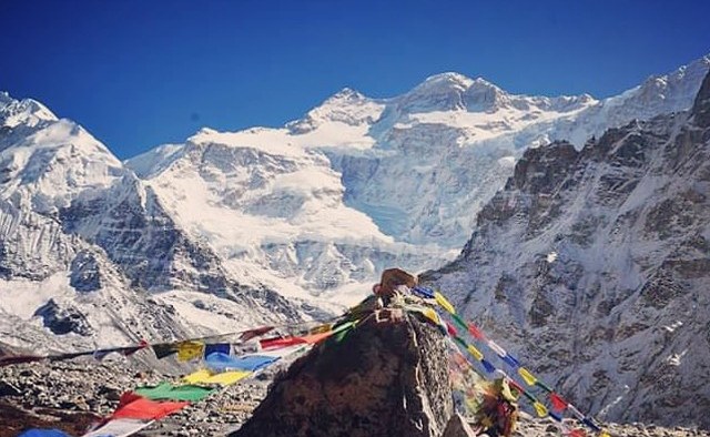
There are Himalayan journeys that begin with a famous name and gradually become something much more personal. The Kanchenjunga trek is one of them. The name belongs to a mountain, but the journey itself belongs to the landscape surrounding it: the cultivated hills of eastern Nepal, cardamom plantations hidden beneath forest, villages connected by suspension bridges, Buddhist settlements in the upper valleys, and, eventually, a country of rock, ice and immense mountain walls.
At 8,586 metres, Mount Kanchenjunga is the third-highest mountain in the world. It stands in the eastern Himalaya along the Nepal-India frontier, and its presence extends far beyond the summit itself. The trekking country around the massif encompasses an extraordinary range of environments, from subtropical forests to high Himalayan valleys. The change is gradual enough that a trekker notices it almost without realising. The green hills of the approach slowly disappear behind you; trees become smaller and less frequent; cultivated land gives way to pasture and bare slopes; and, beyond Kambachen and Lhonak, the landscape is governed increasingly by glaciers, moraine and snow.
That gradual transformation is one of the reasons the Kanchenjunga Trek 2026/2027 deserves more than a brief description on a booking page. Nepal Himalayas Trekking currently offers a 22-day Kanchenjunga Trekking itinerary, following the northern and southern sides of the massif and reaching Pangpema at approximately 5,143 metres. The company's current trip page gives the trek a Moderate to Challenging grade and lists the regular package at US$2,190 per person.
Kanchenjunga Trek at a Glance
| Trek detail | 2026/2027 information |
|---|---|
| Trek | Kanchenjunga Trekking |
| Duration | 22 days |
| Region | Kanchenjunga, eastern Nepal |
| Mountain elevation | 8,586 m |
| Highest trekking point | Pangpema, approximately 5,143 m |
| Route | North and South Base Camp Circuit |
| Difficulty | Moderate to Challenging |
| Best seasons | March to May and September to November |
| Accommodation | Teahouses, lodges and basic accommodation; camping where required |
| Transportation | Domestic flight and road transportation |
| Minimum group size | 2 |
| Current listed package | US$2,190 per person |
For the full commercial itinerary, see Kanchenjunga Trekking 22 Days.
Where Is Kanchenjunga?
Kanchenjunga lies in far eastern Nepal, within Taplejung District and close to the border with the Indian state of Sikkim. The mountain is surrounded by the Kanchenjunga Conservation Area, a protected landscape that contains forests, alpine grasslands, high valleys and glacial terrain.
The approach is one of the defining characteristics of the trek. There is no great city at the trailhead and no immediate transition from airport to alpine village. The journey moves first through eastern Nepal by road and then gradually into the walking country. The present Nepal Himalayas Trekking itinerary approaches through Bhadrapur, the eastern hills, Ilam and Taplejung before reaching the trekking route.
This is why the first few days can feel almost deceptive. You may be expecting the Himalaya to announce itself with snow peaks, yet the lower trail is green, agricultural and inhabited. Cardamom grows beneath the forest canopy. Terraces follow the hillsides. Rivers run through deep valleys, and suspension bridges connect settlements separated by steep mountain terrain.
Only later does the landscape begin to resemble the Kanchenjunga of photographs. The distance between those two landscapes is precisely what gives the trek its depth.
Why Trek to Kanchenjunga?
The obvious answer is the mountain, but the obvious answer is incomplete. Kanchenjunga is a compelling destination for trekkers who want a long Himalayan journey in which the surrounding landscape remains as important as the principal summit. The route enters the Kanchenjunga Conservation Area, passes through villages with different cultural traditions, crosses forests and high valleys, and eventually reaches both the northern and southern sides of the massif. Nepal Himalayas Trekking's current route highlights Pangpema, Ghunsa, Kambachen, Lhonak, the Yalung Valley and the Oktang area among the principal experiences.
The region also receives considerably less trekking traffic than the major routes of Everest and Annapurna. That does not mean that you will walk through an untouched wilderness. People live here, farm here and maintain their own communities. What is less developed is the infrastructure created specifically for large numbers of visitors.
That distinction matters. A trekker coming from the Everest region may notice the difference almost immediately. The lodges are fewer, facilities are simpler, and the trail does not carry the same commercial atmosphere. In the upper valleys, accommodation and food are matters of necessity rather than abundance. For someone who values solitude, landscape and a sense of distance from the familiar trekking circuit, that restraint can be part of the attraction.
The Kanchenjunga North and South Base Camp Route
The full journey takes a broad circuit around the mountain rather than walking to one viewpoint and returning along exactly the same trail. The northern side leads through Ghunsa, Kambachen and Lhonak towards Pangpema. After returning towards Ghunsa, the route crosses the high terrain around Sele La and enters the southern valleys. From Tseram, the trail continues towards Ramche and the Oktang area before descending through Tortong and Yamphudin towards the eastern hills.
The current Nepal Himalayas Trekking route is:
Kathmandu → Bhadrapur → Ilam → Taplejung → Mitlung → Chirwa → Lelep → Amjilosa → Gyabla → Ghunsa → Kambachen → Lhonak → Pangpema → Lhonak → Ghunsa → Sele La → Tseram → Ramche/Oktang → Tortong → Yamphudin → Khebang → Bhadrapur → Kathmandu.
The exact approach and return arrangements can change with road conditions and domestic flight operations, so it is sensible to regard this as the framework of the journey rather than a promise that every transportation connection will operate to the minute.
22-Day Kanchenjunga Trek Itinerary
The itinerary below follows the current 22-day programme published by Nepal Himalayas Trekking.
Day 1: Arrival in Kathmandu
The journey begins in Kathmandu, where you meet the trekking team and settle into the hotel.
There is little reason to turn this first day into an elaborate sightseeing programme. The more useful purpose is preparation. Your guide can go through the route, equipment and arrangements for the days ahead, while you have time to recover from your international flight. The contrast between Kathmandu and the Kanchenjunga region will become considerable within a few days.
Day 2: Fly to Bhadrapur and Drive Towards Ilam
The eastern journey begins with a domestic flight to Bhadrapur, followed by a road journey towards the hills.
Ilam is known for its tea-growing landscape, and the scenery begins to change as the road leaves the lower plains behind. Green ridges, cultivated slopes and scattered settlements replace the urban density of Kathmandu. It is a long day, but it gives the journey an appropriate beginning. You are not simply being transported to a trailhead. You are crossing eastern Nepal and gradually entering the geographical world in which Kanchenjunga stands.
Day 3: Drive to Taplejung
The road continues into increasingly mountainous country. Taplejung serves as an important gateway to the Kanchenjunga region. By this point, the journey has begun to acquire a different rhythm. Markets and settlements remain present, but the surrounding hills have become more dominant and the sense of distance from the major centres of Nepal is increasingly apparent.
The walking has not yet begun, but the landscape is already changing.
Day 4: Taplejung to Mitlung
The trail begins in the lower hills, where the landscape is still green and relatively warm. The route descends towards the valleys and follows the Tamor River through cultivated land, forest and cardamom plantations. Suspension bridges form part of the trail, and the sound of running water remains a constant companion.
It is an interesting beginning to a trek whose later sections will be almost entirely alpine.
Day 5: Mitlung to Chirwa
The trail continues through the lower valleys, rising and falling across cultivated slopes and forest. The walking is not simply an uphill progression. Eastern Nepal's terrain has a habit of placing a descent immediately before another climb, and the first few days therefore require a steady rather than hurried pace.
Cardamom plantations remain a characteristic feature of the landscape. By the time you reach Chirwa, the route feels considerably more remote than it did at the beginning.
Day 6: Chirwa to Lelep
The valley becomes narrower and the forest more pronounced. Streams and waterfalls descend from the steep slopes, while small settlements appear between stretches of woodland. Lelep is one of the more significant settlements within the conservation area and marks another stage in the gradual movement away from the populated lower hills.
The landscape remains green, but the trail is beginning to acquire a distinctly Himalayan character.
Day 7: Lelep to Amjilosa
The trail climbs farther into the mountains. Bamboo and rhododendron become increasingly conspicuous, while the path itself becomes steeper and more uneven in places. The waterfalls falling through the forest provide a reminder of how much water moves through these valleys before the trail eventually reaches the colder country above the tree line.
Amjilosa is small, quiet and comparatively simple. There is a noticeable change in scale here. The settlements are no longer places one might pass through without noticing. Their size reflects the remoteness of the country around them.
Day 8: Amjilosa to Gyabla
The forest continues towards Gyabla, with bamboo, rhododendron and fir appearing along the route. The vegetation begins to reflect the increasing altitude, although the trail is still surrounded by substantial forest. In spring, the rhododendron sections can be particularly attractive. Gyabla is another small mountain settlement, and the surrounding hills provide the first stronger sense that the trail is moving towards the high country.
Day 9: Gyabla to Ghunsa
Ghunsa is one of the most significant settlements on the northern side of the Kanchenjunga route. The cultural atmosphere changes as the trail enters the upper valleys. Prayer flags, mani walls and Buddhist structures become more visible, while the architecture reflects the colder environment and the traditions of the communities living here.
Ghunsa is more than an overnight stop. It is a place where the cultural transition between the lower hills and the upper Himalayan valleys becomes particularly apparent. Nepal Himalayas Trekking's current itinerary deliberately places an acclimatization day here before the route climbs farther towards Kambachen and Lhonak.
Day 10: Acclimatization at Ghunsa
This day should be taken seriously. The purpose is not simply to pause the itinerary. The body needs time to adjust before the route moves towards 4,000 metres and beyond.
A short walk around Ghunsa provides useful movement without the strain of a full trekking day. It also gives you time to inspect equipment, speak with your guide and prepare for colder conditions. At this point, physical symptoms deserve attention. Headache, nausea, dizziness, unusual fatigue or loss of appetite can accompany altitude problems. Any significant change in how you feel should be reported to your guide rather than concealed in the hope that it will disappear.
The mountain does not reward stubbornness.
Day 11: Ghunsa to Kambachen
The trail beyond Ghunsa is markedly different. The forest thins, the slopes become more exposed and rocky sections require greater care. Landslide areas and uneven ground form part of the route, while the surrounding peaks become increasingly prominent.
Jannu is among the mountains that begin to command attention. Kambachen itself is a small settlement surrounded by a landscape that feels considerably harsher than the country below Ghunsa. The comforts of the lower valleys have begun to disappear, and the cold is much more noticeable.
Day 12: Kambachen to Lhonak
This is where the landscape becomes unmistakably high Himalayan. Vegetation becomes sparse. Glacial streams cut across the valley, while moraine and bare rock occupy much of the terrain.
Lhonak is one of the most remote points of the journey. There are few facilities and little sense of the infrastructure associated with Nepal's major trekking routes. The mountains occupy almost every direction of the horizon, and the valley has a severity that is difficult to reproduce in photographs.
Day 13: Lhonak to Pangpema and Back
The walk towards Pangpema is one of the central experiences of the trek. The trail continues through glacial and moraine country as the valley rises towards the northern side of Kanchenjunga. At approximately 5,143 metres, Pangpema is the highest trekking point on the current itinerary.
There is little vegetation here. The landscape is predominantly rock, ice, snow and mountain. The scale of the surrounding peaks is difficult to judge from photographs because there is very little nearby against which to measure them. The mountains seem both close and impossibly large. After spending time at Pangpema, the route returns towards Lhonak.
Day 14: Lhonak to Ghunsa
The descent is welcome, although the trail remains demanding. At lower elevations, breathing becomes easier and the landscape gradually regains vegetation. The return to Ghunsa also marks a psychological transition. The highest northern section has been completed, and the journey is beginning to turn towards the southern side of the massif.
Day 15: Ghunsa to Sele La
The route now climbs again towards the high terrain around Sele La. This section should not be underestimated merely because Pangpema has already been reached. The crossing involves steep and exposed mountain terrain, and conditions can change considerably with snow and weather.
This is one of the places where a knowledgeable guide has practical value beyond navigation. The decision to cross a high route should be based on conditions on the mountain, not on a printed itinerary.
Day 16: Sele La to Tseram
The landscape changes again as the trail descends towards the southern valleys. Tseram lies at a considerably lower elevation than the high crossing, and vegetation gradually begins to return.
The change can be surprisingly quick. A few hours of descent can transform a landscape of rock and snow into one containing forest and running streams.
Day 17: Tseram, Ramche and the Oktang Area
The southern approach offers another perspective on Kanchenjunga. The trail continues towards Ramche and the Yalung Valley, where the surrounding glaciers and southern faces of the massif dominate the landscape.
The excursion towards the Oktang area is particularly worthwhile because it gives trekkers an opportunity to encounter Kanchenjunga from a viewpoint fundamentally different from Pangpema. The mountain is the same. The valley is not. That difference is one of the reasons the complete circuit is so rewarding.
Day 18: Ramche/Oktang to Tortong
The route begins its long descent. The landscape becomes greener, the air warmer and the trail more heavily forested. After the austere environment around Pangpema and the Yalung Valley, the return of substantial vegetation can feel almost excessive.
Tortong provides a relatively low overnight stop compared with the settlements of the preceding days.
Day 19: Tortong to Yamphudin
The trail continues through forest towards Yamphudin. As altitude decreases, cultivated land begins to return and the villages acquire a different character from those in the upper Buddhist valleys.
The southern section therefore provides another cultural transition. The journey that began among the lower eastern communities has come full circle, having passed through forests, high mountain settlements and glacial valleys in between.
Day 20: Yamphudin to Khebang
The trail continues through the lower hills. The landscape is now familiar in some respects, yet it feels remarkably different after the high-altitude section. Forests, streams, farms and village paths have replaced moraine and glaciers. The walking still contains repeated ascents and descents, so the final trekking days should not be mistaken for effortless walks downhill.
Day 21: Khebang to Bhadrapur
The walking section gives way to a long road journey towards Bhadrapur.
Eastern Nepal's roads are subject to weather, traffic and construction conditions, and travel times can therefore change. It is better to allow flexibility here than to organise an international flight around an unrealistically precise road schedule. By the end of this day, the high valleys of Kanchenjunga will already seem strangely distant.
Day 22: Fly from Bhadrapur to Kathmandu
The final flight returns you to Kathmandu. The journey has passed through cultivated hills, forests, Buddhist villages, high valleys, glaciers and the northern and southern approaches to one of the world's highest mountains.
After three weeks in the eastern Himalaya, the return to the capital can feel abrupt. That, in its own way, is part of the journey.
What Is the Kanchenjunga Trek Really Like?
The word remote is used so frequently in descriptions of Himalayan trekking that it can begin to lose its meaning, but in Kanchenjunga it describes something tangible. The region has fewer roads, fewer lodges and fewer services than Nepal's better-known trekking areas, while some sections of the trail lie many hours from substantial medical facilities. Even so, Kanchenjunga is not an empty wilderness. It is a lived-in mountain landscape where agriculture, forests and local communities remain closely connected to the trail. The lower valleys are cultivated, with cardamom forming an important part of the local economy, while bamboo, rhododendron and fir forests cover much of the middle elevations. Villages are linked by narrow mountain paths and suspension bridges, and as the trail climbs towards Ghunsa and the northern valleys, Tibetan Buddhist traditions become increasingly visible in the settlements, prayer flags, mani walls and monasteries. What makes the trek compelling, therefore, is not the absence of human life but the way human settlement gradually gives way to a much wilder mountain environment. The journey moves from cultivated hills and forested valleys into increasingly austere country, where glaciers, high pastures and enormous Himalayan peaks begin to dominate the landscape. Learn more about kanchenjunga trek in our guide.
Kanchenjunga Conservation Area
The trekking route passes through the Kanchenjunga Conservation Area, which covers a large part of Taplejung District.
The ecological range is remarkable. The lower country contains subtropical and temperate forests, while higher elevations lead towards alpine grasslands and high Himalayan environments. Nepal Tourism Board information cited by Nepal Himalayas Trekking records 30 varieties of rhododendron and 48 varieties of orchids in the conservation area, together with a substantial range of wildlife and bird species.
The region is also habitat for species including red panda, musk deer, blue sheep, Himalayan black bear and snow leopard. Seeing any of them, however, is a matter of luck rather than itinerary. A trek through the conservation area is therefore not only a mountain journey. The biological transition from forest to alpine country is part of what makes the route distinctive.
The People and Culture of Kanchenjunga
The cultural landscape changes as markedly as the physical one.
The lower sections contain strong Rai and Limbu cultural influences, while Tibetan Buddhist traditions become increasingly visible as the trail moves towards Ghunsa and the northern valleys. Prayer flags, mani walls, Buddhist structures and traditional houses become part of the scenery.
It is tempting to describe this merely as “cultural immersion,” but the phrase says very little. A more meaningful way to understand the experience is to notice how the geography has shaped settlement. The lower valleys can support agriculture and larger communities. The higher valleys offer much less cultivable land and impose a different way of life. Houses, food, clothing and religious traditions reflect those conditions.
The trek gives you the opportunity to observe that relationship without pretending that a few days of travel make an outsider an authority on local culture. Respect remains essential. Ask permission before photographing people. Follow local customs around monasteries and religious objects. Do not assume that a village exists for the benefit of visitors.
How Difficult Is the Kanchenjunga Trek?
The Kanchenjunga Trek difficulty comes from the length, altitude and remoteness of the journey rather than from technical climbing. The standard trekking route does not require mountaineering skills, but it demands good physical preparation and the ability to remain comfortable in basic mountain conditions for several weeks.
- Long walking days: Most trekking days involve several hours of walking, with repeated ascents and descents. The cumulative fatigue becomes more noticeable as the journey progresses.
- High altitude: The route reaches Pangpema at approximately 5,143 metres, with several nights spent above 4,000 metres. Proper acclimatization and a steady pace are essential at these elevations.
- Remote terrain: The Kanchenjunga region has fewer roads, lodges and medical facilities than the Everest or Annapurna trekking regions. Once you enter the upper valleys, assistance can be several hours or even days away.
- High mountain passes: The route crosses the Sele La area, where steep sections, cold weather and snow can make the trail considerably more demanding depending on the season and conditions.
- Basic accommodation: Facilities become increasingly simple in places such as Kambachen and Lhonak. Trekkers should be prepared for shared facilities, limited hot water and restricted access to electricity and communication.
- Changing terrain: The trail begins among cultivated hills and forests before moving through rocky valleys, moraine, glaciers and exposed Himalayan terrain. Good balance and sure-footedness become increasingly important at higher elevations.
- Previous experience helps: Previous high-altitude trekking experience is certainly useful, but it is not an absolute requirement. Someone who regularly hikes, trains properly and understands the demands of a long mountain journey can prepare well for the trek.
Overall, Kanchenjunga is best suited to trekkers with good endurance who are comfortable with altitude, long walking days and a relatively remote trekking environment. The current Nepal Himalayas Trekking programme classifies the journey as Moderate to Challenging, reflecting these combined demands.
For a more detailed preparation guide, you can link the section to Kanchenjunga Trek Difficulty at the end:
Altitude and Acclimatization
Altitude deserves particular attention because the journey moves from low valleys to more than 5,000 metres within a relatively short period. The acclimatization day at Ghunsa is therefore an integral part of the itinerary.
Common symptoms associated with altitude sickness include headache, nausea, dizziness, unusual fatigue and loss of appetite. If symptoms become significant or worsen, your guide should know immediately.
The sensible approach is unremarkable but effective:
- Walk slowly.
- Drink adequately.
- Eat even when your appetite is reduced.
- Sleep at the planned elevations.
- Avoid unnecessary exertion.
- Tell your guide when something feels wrong.
- If serious symptoms develop, descending takes priority over the itinerary.
- No photograph from Pangpema is worth turning a manageable altitude problem into an emergency.
Best Time for Kanchenjunga Trek 2026/2027
The principal trekking seasons are spring and autumn. Nepal Tourism Board information cited on the current Nepal Himalayas Trekking page identifies March to May and September to November as the strongest periods for the Kanchenjunga Conservation Area.
Spring: March to May
Spring is particularly attractive in the forested sections. Rhododendrons begin to flower, temperatures become more favourable in the lower valleys, and conditions generally improve as the season progresses. April and May are especially appealing for trekkers who want to see the middle elevations in bloom.
Autumn: September to November
Autumn follows the monsoon and generally brings clearer mountain conditions. September can still experience some residual rain, while October and November are commonly favoured for their clearer skies and drier trails. The later November conditions can become cold at high elevations, so appropriate clothing becomes increasingly important.
Winter
Winter is a different proposition. Cold and snow can affect the higher route, and the combination of low temperatures and limited accommodation makes the journey less straightforward.
Monsoon
The eastern Himalaya receives substantial monsoon rainfall. Roads can become difficult, trails can be wet and slippery, and cloud can obscure the mountains. For most travellers, spring and autumn remain the sensible choices for a Kanchenjunga Trek in 2026/2027.
Kanchenjunga Trek Permits 2026/2027
The Kanchenjunga Trek 2026/2027 takes place in a regulated trekking area of eastern Nepal, so trekkers need the appropriate government permits before entering the route. For the present regulations, the Department of Immigration lists the Taplejung restricted area trekking permit at USD 20 per person per week for the first four weeks, with USD 25 per week thereafter. The permit covers specified areas of Phantanglung Rural Municipality, Mikwakhola Rural Municipality and Sirijunga Rural Municipality in Taplejung District.
In addition to the restricted-area permit, trekkers entering the Kanchenjunga Conservation Area need its conservation-area entry permit. The Nepal Tourism Board currently lists the fee at NPR 2,000 per foreign visitor per entry, while SAARC nationals pay NPR 500. The Kanchenjunga routes are also among the trekking areas where a licensed trekking guide and agency-issued TIMS card are required under the revised TIMS provisions.
These permits are not something an independent foreign trekker simply collects at the trailhead. The Department of Immigration states that restricted-area trekking permits are issued through registered trekking agencies, and the agency handles the necessary documentation and application on behalf of the trekking group. For a 2026/2027 departure, it is sensible to have the permit fees and documentation confirmed at the time of booking, since government regulations and charges can be revised. Nepal Himalayas Trekking can arrange the required permits as part of the trekking preparation.
Kanchenjunga Trek Cost 2026/2027
The current 22-day Kanchenjunga Trek package is listed at US$2,190 per person by Nepal Himalayas Trekking. The price covers the principal services required for the organised trek, although the final arrangements should always be checked against your booking confirmation. Because Kanchenjunga is a remote restricted trekking region, the package brings together transportation, accommodation, meals, permits, trekking staff and logistical support that would otherwise be difficult to arrange independently.
What Is Included in the Kanchenjunga Trek Package?
The US$2,190 package currently published by Nepal Himalayas Trekking includes the following:
- Airport transfers: Private vehicle transfers for arrival and departure, including domestic and international airport transfers according to the itinerary.
- Kathmandu accommodation: Three nights in Kathmandu with breakfast.
- Trekking permits: Necessary Kanchenjunga trekking permits and applicable trekking documentation.
- Accommodation during the trek: Teahouse and lodge accommodation throughout the trekking section.
- Three meals a day: Breakfast, lunch and dinner during the trek.
- Fresh fruit: Provided during the trek when available.
- Domestic flights: Return flight arrangements included in the confirmed itinerary.
- Professional trekking guide: A government-registered, English-speaking and first-aid-trained local guide.
- Trekking staff expenses: Staff meals, accommodation, transportation, insurance and necessary equipment.
- First-aid kit: A basic first-aid kit carried by the trekking team.
- Duffel bag: A complimentary agency duffel bag and agency T-shirt.
- Rescue arrangements: Coordination of rescue arrangements when necessary.
- Government taxes and agency charges: Applicable government tax, VAT and agency service charges.
- Achievement certificate: Certificate provided after completing the trek.
- Farewell dinner: Farewell cultural dinner in Kathmandu.
What Is Not Included?
Several personal and international travel expenses remain outside the trekking package. You should therefore budget separately for:
- International airfare
- Nepal visa fees
- Personal travel insurance
- Meals in Kathmandu
- Sightseeing entrance fees
- Personal spending
Drinks, snacks, laundry, hot showers, Wi-Fi and battery charging are also excluded where these services carry an additional charge. Tips for the guide, porter and other trekking staff are not included either.
In particular, travel insurance should not be treated as an optional expense. The trek reaches approximately 5,143 metres at Pangpema and passes through remote mountain valleys, so your policy should cover high-altitude trekking, emergency medical treatment and helicopter evacuation.
For the most accurate Kanchenjunga Trek Cost 2026/2027, it is worth checking the current package and confirming the inclusions for your departure date directly with Nepal Himalayas Trekking.
Accommodation on the Kanchenjunga Trek
Accommodation on the Kanchenjunga Trek 2026/2027 reflects the remote character of the region and becomes progressively simpler as the trail climbs into the higher valleys. In Kathmandu, trekkers stay in a comfortable hotel, while the lower sections of the route are served by locally operated teahouses and lodges where rooms are generally basic but suitable for a good night's rest. As the trail moves beyond Ghunsa towards Kambachen and Lhonak, accommodation becomes more limited because there are fewer settlements and fewer facilities at these elevations. Rooms are usually modest, bathrooms may be shared, and hot showers, electricity and reliable internet cannot always be expected. Meals are available at the teahouses, although the choice becomes narrower in the upper valleys because supplies have to be transported considerable distances. The simplicity of the accommodation is part of what makes the Kanchenjunga journey different from the more developed trekking routes of Nepal, where larger lodges and a wider range of facilities are available. Nepal Himalayas Trekking arranges teahouse and lodge accommodation along the route, with camping used where required by the itinerary and local conditions.
Food Along the Trail
Food on the Kanchenjunga Trek 2026/2027 is closely tied to the remoteness of the route and the small settlements through which the trail passes. In the lower and middle sections, teahouses generally serve familiar Nepali and Tibetan-influenced meals, with dal bhat, momos, thukpa, Tibetan bread, noodles, fried rice, chowmein, pasta, potatoes, eggs, porridge and soup among the common choices. As the trail climbs towards Ghunsa, Kambachen, Lhonak and Pangpema, the menu naturally becomes more limited because food and other supplies have to be carried into increasingly remote valleys. Dal bhat remains one of the most dependable meals on the trek, providing a substantial combination of rice, lentils and vegetables that suits long days of walking. Breakfasts are usually simpler, with options such as porridge, eggs, bread or pancakes, while tea, coffee and other hot drinks are widely available at the lodges. Carrying a few personal snacks such as nuts, dried fruit, chocolate or energy bars is sensible, particularly for the longer days towards Pangpema and the higher sections of the route. The food is not intended to provide the variety of a city restaurant, but it is generally practical, filling and well suited to the physical demands of a long Himalayan trek.
Drinking Water on the Kanchenjunga Trek
Drinking water requires some planning on the Kanchenjunga Trek 2026/2027, particularly as the route moves into the more remote and higher valleys. Water is available from local taps, streams and other natural sources along parts of the trail, but untreated mountain water should not be assumed to be safe to drink. Trekkers should carry a reliable purification method, such as a portable water filter, purification tablets or suitable purification drops, and use it whenever the safety of the source is uncertain. A reusable water bottle or hydration system is also preferable to relying on disposable plastic bottles throughout the journey, particularly because the trek passes through the environmentally sensitive Kanchenjunga Conservation Area. Keeping sufficient water with you is especially important on longer and higher sections of the route, where reliable water sources and teahouses are less frequent. With a little preparation, staying hydrated becomes straightforward and also reduces unnecessary plastic waste along the trail.
Internet, Mobile Network and Electricity
Connectivity on the Kanchenjunga Trek 2026/2027 becomes increasingly limited as you move away from the lower villages and into the high valleys. It is better to prepare for periods without reliable internet, mobile service or electricity rather than depending on regular connectivity throughout the trek.
- Mobile network: Mobile coverage is available in some lower settlements, but the signal becomes weak or unavailable in remote sections, particularly around the higher valleys. Do not assume that you will be able to make a call whenever you need one.
- Wi-Fi: Some teahouses may offer Wi-Fi for an additional charge, but the connection can be slow or unavailable. Internet access should be regarded as a convenience rather than something you can rely on every evening.
- Electricity: Electricity is available in many villages, although charging facilities become less dependable at higher elevations. Some lodges may charge an additional fee for charging phones, cameras or other devices.
- Power bank: A good-capacity power bank is worth carrying. It becomes particularly useful on longer sections where you may spend a night or two without dependable access to charging.
- Keep documents offline: Before leaving Kathmandu, download your important travel documents to your phone and keep additional copies available offline. These should include your passport, travel insurance, flight details, emergency contacts, trekking itinerary and permit information.
- Prepare for communication gaps: Tell family or friends before departure that there may be periods when you cannot contact them. This is especially important on a remote trek such as Kanchenjunga, where the absence of a signal is a normal part of travelling through the upper valleys.
A little preparation makes the lack of connectivity much less troublesome. The Kanchenjunga trek is one of those journeys where being temporarily disconnected from everyday communication is part of the experience, rather than an inconvenience that needs to be solved at every stop.
Guide and Porter Support
Guide and porter support is particularly valuable on the Kanchenjunga Trek 2026/2027 because the route enters a restricted and remote mountain region, reaches approximately 5,143 metres at Pangpema, and includes sections where weather and trail conditions can change quickly. A professional guide does far more than lead the way; they help manage the daily pace, accommodation arrangements, route decisions, altitude concerns and communication with local communities, while also recognising when weather or physical conditions require a change in plan. A porter carries the heavier portion of your luggage, allowing you to walk with a lighter daypack containing water, warm clothing, personal medication, documents and other essentials. For a long trek through the Kanchenjunga region, having experienced local staff can make the journey considerably safer, more organised and more comfortable, particularly in the higher valleys where services are limited. Nepal Himalayas Trekking provides professional trekking staff as part of its organised Kanchenjunga trekking programme, with guide and porter arrangements included according to the confirmed package.
Travel Insurance
Insurance deserves particular attention on this trek because of the altitude and remoteness. The route reaches approximately 5,143 metres at Pangpema and enters areas where road access and medical facilities are limited. Your insurance should therefore cover high-altitude trekking and emergency evacuation.
Before purchasing a policy, check:
- The maximum altitude covered
- High-altitude trekking
- Emergency medical treatment
- Helicopter evacuation
- Hospitalisation
- Trip cancellation
- Trip interruption
- Personal accident
- Baggage loss or delay
An ordinary travel policy should not be assumed to cover a high-altitude trek. Keep your insurer's emergency contact details accessible throughout the journey.
What Should You Pack?
The Kanchenjunga route passes through several climate zones, so the packing list needs to accommodate both warm lower valleys and cold high-altitude conditions.
Clothing
- Thermal base layers
- Fleece jacket
- Down or insulated jacket
- Waterproof shell
- Waterproof trousers
- Trekking trousers
- Warm hat
- Sun hat
- Gloves
- Trekking socks
Footwear
- Well-broken-in trekking boots
- Camp shoes
- Spare socks
Trekking equipment
- Backpack
- Daypack
- Warm sleeping bag
- Trekking poles
- Headlamp
- Water bottles
- Water purification system
- Duffel bag
- Power bank
Personal items
- Sunglasses
- Sunscreen
- Personal medication
- Basic first-aid supplies
- Toiletries
- High-energy snacks
- Passport copies
- Insurance documents
The current Nepal Himalayas Trekking packing guidance recommends layered clothing, waterproof footwear, a cold-weather sleeping bag, trekking poles, headlamp, water purification equipment and other basic high-altitude equipment.
What Can You See on the Kanchenjunga Trek?
The mountain itself is only one part of the scenery. The lower trail passes through cardamom-growing country and forest. Rhododendron becomes increasingly prominent at middle elevations. Above Kambachen and Lhonak, the trees disappear and the landscape becomes dominated by rock, glacier and moraine.
- The cultural scenery changes alongside the natural one.
- Ghunsa introduces a strong Buddhist character.
- The Yalung Valley presents another face of the Kanchenjunga massif.
- The lower southern trail returns to forests, farms and settlements.
And between these environments lie the mountain views that have brought trekkers here in the first place.
Responsible Travel in Kanchenjunga
The Kanchenjunga Conservation Area is a living landscape rather than simply a trekking destination. The route passes through forests, agricultural land, wildlife habitat and villages where local communities continue their everyday lives. Responsible trekking therefore requires a little more consideration, particularly in a region where waste disposal and other facilities are limited.
- Carry a reusable water bottle: Using a refillable bottle reduces the amount of plastic waste produced during the trek. Carry a reliable purification method so you can safely treat water from suitable local sources.
- Take your waste with you: Waste collection facilities become limited in the higher valleys. Keep wrappers, batteries, tissues and other rubbish in your daypack until you reach an appropriate disposal point.
- Limit single-use plastic: Avoid buying unnecessary plastic bottles and individually packaged items wherever practical. A little preparation before the trek can considerably reduce the waste you produce.
- Respect wildlife: The conservation area provides habitat for species including red pandas, musk deer, blue sheep and other Himalayan wildlife. Keep your distance, avoid feeding animals and never leave food or rubbish on the trail.
- Respect religious places: Monasteries, chortens, mani walls, prayer flags and other Buddhist structures have significance for local communities. Follow local customs and avoid touching or moving religious objects.
- Ask before taking photographs: People and villages are not tourist attractions. Ask permission before photographing local residents, particularly children, monks and people engaged in religious activities.
- Support local communities: Staying in locally operated teahouses, eating locally prepared food and purchasing appropriate local products allows more of your travel expenditure to remain within the communities along the route.
- Respect local customs: The trek passes through communities with different cultural traditions, so dress and behave respectfully, particularly around monasteries, homes and religious ceremonies.
- Protect the trail: Stay on established paths where possible and avoid damaging vegetation. In a fragile mountain environment, even small disturbances can take considerable time to recover.
Responsible trekking in Kanchenjunga ultimately means leaving the landscape and communities with as little disruption as possible. The mountains will remain long after a trekker has returned home, while the forests, villages and conservation area continue to support the people and wildlife of the region.
Kanchenjunga Trek vs Everest Base Camp Trek
The Kanchenjunga Trek and Everest Base Camp Trek offer two very different ways of experiencing the Nepal Himalaya. Kanchenjunga lies in eastern Nepal and takes trekkers into a considerably quieter and more remote part of the country, where the route passes through forests, traditional villages and high valleys before reaching the northern and southern sides of the 8,586-metre Kanchenjunga massif. The Everest route, by comparison, follows the well-established trail through the Khumbu region towards Everest Base Camp and Kala Patthar. Although Kala Patthar reaches a higher elevation than Pangpema, the greater challenge of Kanchenjunga comes from the length of the journey, the remoteness of the upper valleys, the simpler accommodation and the less developed trail infrastructure. Everest offers easier access, more established teahouses, greater connectivity and a much larger trekking community, while Kanchenjunga provides a quieter experience with fewer trekkers and a stronger sense of distance from the heavily travelled Himalayan routes.
The cultural experience differs as well. The Everest region is closely associated with Sherpa communities and Tibetan Buddhist traditions, while Kanchenjunga introduces trekkers to the cultural diversity of eastern Nepal, including Rai and Limbu communities in the lower sections and Buddhist traditions in settlements such as Ghunsa. Kanchenjunga is therefore particularly suited to trekkers who value solitude, varied landscapes and a longer expedition-style journey, whereas Everest may be the better choice for travellers whose primary goal is to reach the world's highest mountain through a well-established trekking route. Neither destination is inherently better than the other; the more appropriate choice depends on whether you want the familiarity and infrastructure of the Everest trail or the quieter, more remote character of Kanchenjunga.
Kanchenjunga Compared With Manaslu
The Kanchenjunga Trek and Manaslu Circuit Trek both appeal to trekkers who want to spend time in quieter parts of the Nepal Himalaya, but the character of the two journeys is quite different. The Manaslu Circuit follows a more defined circuit around Mount Manaslu at 8,163 metres, with the dramatic crossing of Larkya La at approximately 5,106 metres forming the central high-altitude challenge. Kanchenjunga takes trekkers farther east into the Kanchenjunga Conservation Area, where the journey is longer and more geographically varied, passing from cultivated hills and dense forests into remote Himalayan valleys before reaching the northern and southern sides of the 8,586-metre Kanchenjunga massif. The cultural experience differs as well. Manaslu is particularly known for its Tibetan Buddhist communities and villages along the Budhi Gandaki Valley, while Kanchenjunga brings together the cultural traditions of eastern Nepal with the Buddhist influence found in the higher settlements around Ghunsa and beyond. Manaslu may suit trekkers who want a challenging circuit centred around a high mountain pass, whereas Kanchenjunga is better suited to those looking for a longer, quieter and more remote Himalayan journey with greater variation in landscape. Both require good physical preparation, but Kanchenjunga demands additional patience because of its distance, limited infrastructure and more isolated trekking environment.
Is Kanchenjunga Suitable for First-Time Trekkers?
There is no simple yes or no. A physically fit person without previous Himalayan trekking experience can prepare for the journey with professional support, but Kanchenjunga is not the route I would recommend to someone who has never spent several consecutive days walking in mountainous terrain.
The difficulty is cumulative. You need to remain comfortable with long walking days, altitude, simple accommodation, cold conditions and periods without reliable communication. Previous experience is helpful, but preparation matters more than the label “beginner.” A person who has spent months training on hills may be better prepared than an experienced traveller whose previous trekking consisted mainly of short, comfortable routes.
Responsible Travel in Kanchenjunga
The Kanchenjunga Region conservation area is not merely a backdrop for trekking. It is a living environment. The trail passes through forests, farms and villages where people live throughout the year. Waste, plastic, batteries and other discarded materials therefore have consequences that extend beyond the trekker's own journey.
- Carry reusable bottles.
- Dispose of waste properly.
- Avoid unnecessary plastic.
- Do not disturb wildlife.
- Respect religious sites.
- Ask before photographing people.
- Support local lodges and services where possible.
Most importantly, remember that the region belongs to the communities who live there long after visitors have gone home.
Why Choose Nepal Himalayas Trekking for Kanchenjunga?
This section should remain factual rather than turning into a parade of marketing adjectives. Nepal Himalayas Trekking currently operates a 22-day Kanchenjunga Trekking programme, with a minimum group size of two and a current listed price of US$2,190 per person. The company's Kanchenjunga regional page also lists the trek at 22 days and describes the grade as Moderate to Challenging.
The company also maintains supporting information covering Kanchenjunga Trek Cost, permit information and practical preparation. That collection of information is useful to a traveller because the booking page answers the commercial ques