

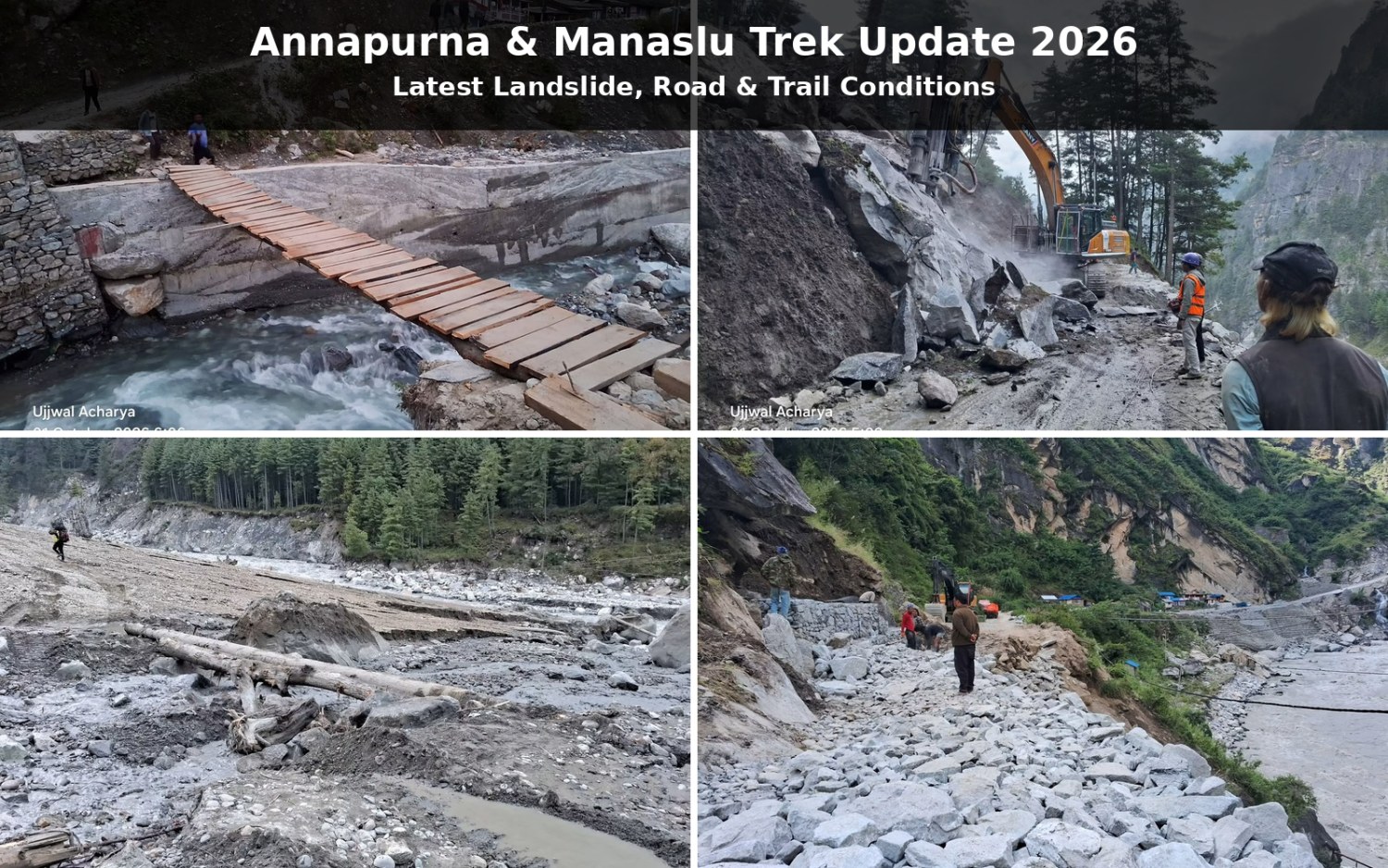
If you are planning the Annapurna Circuit Trek or Manaslu Circuit Trek in October 2026, it is important to check the latest route conditions before departure. Continuous rainfall across parts of central and western Nepal has caused flooding, landslides, river erosion, damaged roads and bridges, and heavy snowfall at higher elevations. These conditions have affected both local communities and trekkers, particularly around Manang on the Annapurna Circuit and the high-altitude sections of the Manaslu Circuit. The current situation is changing quickly, so a normal autumn trekking forecast should not be treated as a substitute for a current route update.
The two trekking regions are experiencing different problems. On the Annapurna Circuit, serious disruption has developed around Chame and Upper Manang, where debris from the Ghatte River entered the Marsyangdi, causing the river to rise around a motorable bridge that provides the main road connection to Upper Manang. Higher on the route, heavy snowfall has affected Thorong La, forcing some trekkers attempting the pass to turn back. On the Manaslu Circuit, an earlier problem around Namrung was addressed through local restoration work, and the Nepal Tourism Board confirmed that the affected structures had been restored to a condition suitable for trekking and the previous restriction lifted. However, subsequent snowfall has created a new problem around Larke Pass, where heavy snow is currently blocking the high-altitude crossing.
This update therefore looks at more than whether a trek is simply “open” or “closed.” It explains the latest Annapurna and Manaslu trail conditions, landslides, road access, damaged bridges, Thorong La and Larke Pass conditions, government response, local community involvement, and what these developments mean for October 2026 trekking plans. It also looks at how conservation agencies and local communities are approaching tourism and development in these mountain regions, where infrastructure needs to support local livelihoods without increasing pressure on fragile landscapes.
Current Annapurna & Manaslu Trek Status
As of today, neither the Annapurna Circuit nor Manaslu Circuit should be described simply as completely open or completely closed. Conditions differ significantly between lower settlements, roads, walking trails and high mountain passes. On Annapurna, the main immediate problems are the blocked road and bridge around Chame and Upper Manang and heavy snowfall around Thorong La. On Manaslu, the earlier Namrung infrastructure problem was addressed, but heavy snowfall has now blocked Larke Pass, creating a separate high-altitude disruption.
| Route / Section | Current situation | Main concern |
|---|---|---|
| Annapurna Circuit | Significant disruption in parts of the route | Flooding, landslides, road and bridge damage, snowfall |
| Chame – Upper Manang | Main road access currently blocked | Marsyangdi flooding and debris |
| Thorong La | Heavy snowfall affecting crossings | Snow and high-altitude weather |
| Manaslu Circuit | Conditions remain dynamic | Rain, snow and high-pass access |
| Namrung | Earlier damaged structures restored | Current local conditions still need checking |
| Larke Pass | Heavy snow currently blocking the crossing | High-altitude snowfall |
The status can change as rainfall decreases, river levels fall, debris is cleared and snow conditions change. For this reason, trekkers should use this article as a current situation update, not as a permanent declaration of route status. If your departure is several days or weeks away, check the route again immediately before travelling.
What Happened on the Annapurna Circuit?
The recent Annapurna Circuit disruption followed several days of continuous rainfall, which caused flooding, landslides and river erosion in the Manang area. One of the most serious incidents occurred around Chame, where the Ghatte River carried a large quantity of mud, rocks, sand and other debris into the Marsyangdi River. The debris partially obstructed the river and caused water levels to rise around a motorable bridge. The river subsequently began flowing around both sides of the bridge, increasing concerns about the structure and nearby houses.
The affected bridge and road are particularly important because they provide the main road connection between Chame and Upper Manang and are also used by travelers following the Annapurna Circuit. The flooding has damaged the road at several points, including sections between Chame and Bhratang, while debris has entered homes in parts of the area. Residents on the opposite side of the river were temporarily isolated, and some families moved to safer locations as floodwaters and river erosion increased.
The problem has also extended to the higher trekking route. Continuous rain in lower areas has been accompanied by heavy snowfall in upper Manang, creating difficult conditions around Thorong La. ACAP officials reported that 226 foreign tourists had reached upper Manang, with 44 having returned, while more than 150 tourists who had crossed or attempted to cross Thorong La returned to Manang as snowfall made the high-altitude route difficult. The current Annapurna situation is therefore a combination of flood and infrastructure damage at lower elevations and snow-related disruption at higher elevations.
Is the Annapurna Circuit Completely Closed?
No single closure applies to the entire Annapurna Circuit, but several important sections are currently disrupted. The most serious lower-route problem is around Chame and Upper Manang, where the road and bridge have been affected by flooding and river debris. At higher elevation, heavy snowfall around Thorong La has made crossing difficult. This means some sections may remain accessible while other sections require current assessment, route adjustments or waiting for conditions to improve.
This distinction is important because the Annapurna Circuit contains roads, walking trails, bridges, villages and high mountain passes, all of which can respond differently to extreme weather. A damaged road does not automatically mean every walking trail is closed, while a damaged bridge or difficult pass can prevent trekkers from continuing their planned itinerary. Anyone preparing to travel now should therefore check the specific sections between Chame, Manang, Yak Kharka, Thorong Phedi and Thorong La, rather than relying on a general statement that the Annapurna Circuit is open. Where an affected section remains suitable for movement, an experienced local team may be able to use an alternative trail, temporary crossing, additional walking time or an adjusted overnight stop, depending on the conditions at that time.
What Is the Current Annapurna Circuit Trail Condition?
The current trail condition varies according to elevation. Lower sections around Manang have been affected primarily by rain, flooding, landslides, erosion and damaged access infrastructure, while higher sections are experiencing winter-like conditions because of fresh snowfall. The result is a route where one section may be affected by water and debris while another is affected by snow and visibility. Trekkers already in the region have therefore faced delays and difficulty continuing according to their original itineraries.
The Thorong La section requires particular attention because the pass reaches approximately 5,416 meters. Recent snowfall has already caused trekkers to return rather than continue across the pass. Even if road conditions around Chame improve, the higher route can remain difficult until weather and snow conditions become suitable for a crossing. For this reason, trekkers should obtain a fresh local update before approaching Thorong Phedi and Thorong La instead of assuming that the normal October trekking season guarantees suitable conditions. Our team also assesses the latest trail, weather and local information before deciding whether a planned section should be continued or adjusted.
What Is Happening Around Chame and Upper Manang?
The Chame–Upper Manang road and bridge have become one of the main current trouble spots on the Annapurna Circuit. Flood debris carried from the Ghatte River partially blocked the Marsyangdi, causing the river to rise and flow around the bridge. The bridge was submerged, while nearby houses were exposed to flooding and erosion. The road from Chame toward Bhratang has also been damaged at several points, adding another obstacle to transportation into Upper Manang.
Authorities began clearing the river and road using excavators and other heavy machinery, while security personnel and local residents joined the work. A temporary pedestrian structure was also built across the Ghatte River using electricity poles, although vehicles cannot use it. As of September 30, the road between Chame and Upper Manang was still effectively blocked, and authorities could not give a definite time for reopening.
Earlier in the week, some residents who had moved to safer areas returned as river levels fell, but the situation remained unsettled. By September 30, the Marsyangdi was still flowing around the affected bridge, and authorities continued clearing debris while monitoring the risk to nearby homes and infrastructure. This is important for trekkers because reopening a road after a flood is not simply a matter of removing mud from the surface. River channels, bridges, slopes and road foundations may all need to be assessed before normal movement resumes. The Chame and Upper Manang area is also relevant to trekkers planning extended Annapurna itineraries such as **Nar Phu Valley and Tilicho Lake**, because access to these routes is connected with the wider Manang trail and transportation network. Current conditions should therefore be checked before adding these side routes to an itinerary.
What Is the Current Thorong La Condition?
Thorong La Pass is currently affected by heavy snowfall, and several trekkers have already turned back after attempting the crossing. The pass is one of the highest points on the Annapurna Circuit, at approximately 5,416 meters, so fresh snow can quickly change trail conditions, visibility and the amount of time required for the crossing. ACAP officials reported that more than 150 tourists who had crossed or attempted to cross Thorong La returned to Manang as conditions deteriorated.
This does not mean that Thorong La will remain inaccessible throughout October. Mountain weather can change considerably over a short period, and the condition of the pass should be assessed close to the actual crossing date. Trekkers should pay attention to fresh snowfall, visibility, trail coverage, wind and local guidance rather than deciding whether the pass is suitable based only on the calendar. If conditions are unsuitable on the planned crossing day, the itinerary should be adjusted according to the latest local assessment rather than attempting to force the crossing.
What Happened on the Manaslu Circuit?
The Manaslu Circuit experienced an earlier disruption around Namrung after flooding and landslides damaged important infrastructure along the trekking route in Chumnubri Rural Municipality-4. Reporting from early September said that two bridges were swept away, disrupting local connectivity and tourist movement in the area. The District Administration Office initially advised trekkers to avoid or suspend travel in the affected section while the situation was assessed.
Local residents, ward representatives and the Manaslu Conservation Area Project responded by creating an alternative trail and temporary wooden bridge around the damaged crossing. Movement resumed after the temporary route was constructed, and the Nepal Tourism Board later confirmed that the damaged structures around Namrung had been restored to a condition suitable for trekking and that the earlier restriction had been lifted. This is a useful example of how local knowledge and community action can restore movement after a sudden trail disruption.
The Namrung situation, however, should not be confused with the latest high-altitude conditions. After the earlier restoration, further rain and snowfall affected the Manaslu region. The current major concern is around Larke Pass, also called Larkya La, which sits at approximately 5,106 meters and forms the high crossing between the Manaslu side of Gorkha and the Manang side. Heavy snowfall has covered the trail and currently prevents normal movement across the pass.
Is the Manaslu Circuit Open Right Now?
The Manaslu Circuit should currently be considered condition-dependent rather than simply open or closed. The Nepal Tourism Board confirmed that the earlier restriction around Namrung was lifted after damaged structures were restored. However, current heavy snowfall at Larke Pass is preventing normal passage over the high crossing.
For trekkers planning the Manaslu Circuit, the most important sections to check before departure are Namrung, Lho, Samagaun, Samdo, Dharamsala and Larke Pass. The condition of lower villages and trails can be different from the high pass. If the snow around Larke Pass eases, the situation can change, but trekkers should not assume normal autumn access until current local information confirms that the crossing is practical. Where a lower section is affected but remains suitable for movement, an experienced local team can assess the route and make practical itinerary adjustments according to the actual trail condition.
What Is the Current Manaslu Circuit Trail Condition?
The earlier damage around Namrung has been addressed, but the current concern is the heavy snow covering the higher trail toward Larke Pass. Because the pass reaches more than 5,000 meters, a significant amount of fresh snow can make route finding and crossing considerably more difficult than conditions in lower villages. The current disruption is therefore concentrated at high elevation rather than representing a blanket closure of every Manaslu trail.
Trekkers planning an October Manaslu journey should therefore check conditions progressively as they move higher. Information from a lower village may not accurately represent the conditions at Dharamsala or Larke Pass several hours or days later. A local guide, conservation-area information point and current weather assessment are particularly useful before attempting the high crossing. Our team also follows these local updates and can make practical itinerary adjustments when changing trail conditions affect the original plan.
What Is the Difference Between Road and Trail Conditions?
When checking a Nepal trekking route update, road conditions and trekking-trail conditions should always be considered separately. A road can be blocked while a parallel walking trail remains usable, while a damaged bridge, active landslide or heavy snowfall can affect both vehicles and pedestrians. This distinction is especially important on the Annapurna Circuit because road infrastructure is now integrated into many sections of the traditional trekking route.
The current situation provides clear examples. Around Chame, floodwater and debris have disrupted the road and bridge connecting Upper Manang, while higher on the same circuit heavy snowfall is affecting Thorong La. On Manaslu, the earlier Namrung infrastructure damage was addressed through a temporary alternative route and later restoration, while the current Larke Pass problem is related mainly to heavy snow. A route update therefore needs to identify exactly what is blocked, where it is blocked, and whether the problem affects vehicles, pedestrians, trekkers or high-pass crossings.
How Are the Government and Local Communities Responding?
The current response around Manang shows a combination of government agencies, security forces, local government and residents working together to restore access and reduce immediate risk. The district administration has deployed excavators and other machinery to clear debris from the Marsyangdi River, while the Nepali Army, Armed Police Force and Nepal Police have joined the operation. Residents have also participated in clearing work, and a temporary pedestrian structure was constructed across the Ghatte River after flooding damaged roads and bridges.
The response is being carried out cautiously because simply forcing a river open can create additional damage. Authorities have been widening the river channel and removing debris while monitoring the bridge and nearby houses rather than immediately using explosives. This reflects an important part of mountain disaster management: restoring access while avoiding actions that could destabilize already vulnerable infrastructure or riverbanks. The district administration has also continued monitoring changing river levels and local risks as the situation develops.
How Are Annapurna and Manaslu Approaching Sustainable Development?
Sustainable development in these trekking regions is closely connected with local participation, conservation and tourism income. The Annapurna Conservation Area uses an integrated conservation and development approach in which local communities play an important role in conservation and tourism-related development. NTNC's Annapurna programme specifically focuses on areas such as Manang and Ghandruk through integrated tourism management and development activities intended to benefit local communities and the environment. Its stated objectives include sustainable social and economic development and tourism with minimal negative impacts on natural, socio-cultural and economic environments.
The same principle is visible in Manaslu. The Manaslu Conservation Area Project follows an integrated conservation and development approach, with local participation in natural-resource management, biodiversity conservation, livelihoods and sustainable tourism. Conservation Area Management Committees work with the programme on biodiversity, local livelihoods and tourism management, while the project aims to strengthen the ability of local communities to manage natural resources sustainably. Tourism is also an important economic activity for communities along the trekking route.
Why Does Local Community Participation Matter for Trekking?
Local communities are not simply residents living beside the trekking route. They are part of the system that operates lodges, provides food and transport, maintains local services and responds when roads or trails are disrupted. In Annapurna, conservation and tourism programmes have supported community participation in tourism management and local development. The wider conservation model is built around local involvement, natural-resource management and connecting tourism with community livelihoods.
The Manaslu model similarly emphasizes local involvement in conservation and sustainable tourism. The Manaslu Conservation Area Project works with local Conservation Area Management Committees to conserve biodiversity, improve livelihoods and maintain sustainable tourism practices. This becomes particularly important during events such as floods and landslides because local residents often have immediate knowledge of trail conditions, river behavior, damaged structures and changes in access. The temporary alternative trail and wooden bridge created after the Namrung flood provide a recent example of local action restoring movement along the trekking route.
What Does Sustainable Development Mean After These Landslides?
Recent flooding and landslides show why sustainable development in mountain trekking areas needs to include disaster resilience as well as tourism growth. Roads and bridges are essential for local communities and trekkers, but rebuilding them in hazard-prone areas requires attention to river channels, slope stability, changing rainfall patterns and the increasing exposure of Himalayan infrastructure to extreme weather. Recent damage around Manang has again demonstrated how quickly river behavior can affect roads, bridges, houses and access routes.
For trekking destinations, sustainable development therefore means more than building additional roads or accommodation. It includes resilient infrastructure, responsible trail management, waste reduction, protection of natural and cultural resources, local employment, community decision-making and better disaster preparedness. Tourism can provide important income to mountain communities, but long-term development needs to protect the landscapes and local systems that make the Annapurna and Manaslu regions viable trekking destinations in the first place.
Can You Trek the Annapurna Circuit in October 2026?
October is normally one of Nepal's main trekking months, but the beginning of October 2026 requires additional route checking because of the current conditions. The latest situation around Manang includes flooding, road and bridge disruption, and heavy snowfall toward Thorong La. Trekkers have already been unable to continue normally in some sections, while others have returned from the high pass because of snow.
This does not mean that the entire October trekking season has been cancelled. Conditions may improve as rainfall decreases, river levels fall, damaged access is restored and snow conditions change. **Annapurna Circuit itineraries, including plans that extend toward Nar Phu Valley or Tilicho Lake, can be considered according to the actual condition of the route at the time of travel.** Travelers with an early October departure should obtain a fresh local update before travelling toward Manang and before attempting Thorong La. A normal seasonal forecast is useful for planning, but it cannot replace current information about a specific bridge, road or mountain pass.
Can You Trek the Manaslu Circuit in October 2026?
October is normally one of the main trekking periods for Manaslu, but current snowfall means that the high-altitude section requires particular attention. The earlier Namrung infrastructure problem was addressed, and the Nepal Tourism Board confirmed that the restriction on the affected section had been lifted. However, heavy snow has now blocked Larke Pass, so trekkers cannot assume that the entire circuit is currently operating under normal autumn conditions.
If conditions improve, the situation can change relatively quickly. Before beginning the trek, travelers should confirm the latest information around Samagaun, Samdo, Dharamsala and Larke Pass, especially if their itinerary depends on crossing the pass on a particular date. Allowing some flexibility in the itinerary is useful because weather-related delays can affect both the trekking schedule and transportation after the trek. Our team can assess the latest local conditions before departure and adjust the route or schedule where necessary.
What Should Trekkers Do Before Starting Annapurna or Manaslu?
The most important step is to check the specific route shortly before departure rather than relying on an old social media post or a general statement that October is a good trekking season. On Annapurna, check the latest situation around Besisahar, Chame, Upper Manang and Thorong La. On Manaslu, check Machha Khola, Namrung, Samagaun, Samdo, Dharamsala and Larke Pass.
Trekkers should also keep some flexibility in their schedule. A flood, landslide, damaged bridge or snowfall can add unexpected time to a Himalayan journey even when the overall trekking season remains suitable. Carry suitable rain protection, warm layers, proper trekking footwear and equipment for wet or snowy conditions, and follow the instructions of local authorities, conservation-area officials and your trekking guide when conditions change. Our team also checks local information and assesses the terrain before moving through an affected section rather than relying only on a fixed itinerary.
Should You Delay Your Annapurna or Manaslu Trek?
There is no single answer for every traveler because the conditions can change rapidly. For someone departing immediately, the current situation around Chame, Upper Manang and Thorong La deserves particular attention on Annapurna, while Larke Pass is the critical high-altitude concern on Manaslu. These are current route conditions rather than permanent closures.
Rather than deciding solely from the name of the trek or the month on the calendar, make the decision using the latest information for your actual departure date. If a section remains affected, an experienced local trekking team can assess whether the itinerary can be adjusted, delayed or rerouted based on the conditions available at that time. This may involve using an alternative trail, changing a walking day, arranging different transportation or allowing additional time where appropriate.
What Does the Current Situation Mean for October 2026 Trekkers?
The recent weather does not automatically mean that the entire autumn trekking season in Nepal is cancelled. It means that late September and early October 2026 require closer monitoring because both regions have experienced unusual combinations of rainfall, flooding and snowfall. The Annapurna Circuit currently has major infrastructure and high-pass concerns, while Manaslu has a restored Namrung section but a current snow blockage at Larke Pass.
The situation also shows why current local information is particularly valuable in the Himalayas. A trail can be repaired while a new weather problem develops elsewhere, or a road can reopen while a high pass remains covered in snow. Trekkers planning October departures should therefore build their plans around current route information, flexible schedules, proper trekking equipment and local guidance, rather than assuming that conditions at the end of September will remain unchanged throughout the month.
Frequently Asked Questions
Is the Annapurna Circuit open right now?
The Annapurna Circuit is experiencing significant disruption in parts of the route as of September 30, 2026. Flooding and landslides have affected road and bridge access around Chame and Upper Manang, while heavy snowfall is affecting the higher route toward Thorong La.
Is the Manaslu Circuit open right now?
The earlier restriction around Namrung was lifted after the damaged structures were restored. However, heavy snowfall is currently blocking Larke Pass, so the entire Manaslu Circuit should not be considered to be operating under normal autumn conditions at present.
Did landslides close the Annapurna Circuit?
Flooding and landslides have disrupted important sections of the Annapurna Circuit, especially around Chame and Upper Manang. It is more accurate to identify the affected sections than to describe the entire circuit as permanently closed.
Has the Manaslu landslide and flood damage been repaired?
The damaged structures around Namrung were restored to a condition suitable for trekking, and the Nepal Tourism Board confirmed that the earlier restriction was lifted. Local residents and project officials also helped establish an alternative trail and temporary wooden crossing after the September flood. The current Larke Pass problem is a separate snowfall-related disruption.
Is Thorong La open right now?
Thorong La is currently affected by heavy snowfall, and trekkers attempting the crossing have turned back as conditions deteriorated. The current situation should be checked again before attempting the pass.
Is Larke Pass open right now?
As of September 30, heavy snowfall is blocking Larke Pass. The pass is approximately 5,106 meters high, and heavy snow has covered the trail, preventing normal movement across the high route.
Can I trek the Annapurna Circuit in October 2026?
It may be possible as conditions improve, but early October departures require a current route check because of the present flooding, infrastructure damage and snowfall around Thorong La. The itinerary may need adjustment depending on the condition of the affected sections.
Can I trek the Manaslu Circuit in October 2026?
It may be possible if the current weather-related disruption improves. The Namrung section has been restored, but Larke Pass is currently blocked by snow, so trekkers should check the latest conditions before departure.
Are the Annapurna and Manaslu problems the same?
No. Annapurna is currently dealing mainly with flooding, landslides, road and bridge disruption around Manang and heavy snowfall toward Thorong La. Manaslu's earlier Namrung infrastructure problem was addressed, while the current major disruption is heavy snowfall around Larke Pass.
How are local communities involved in sustainable trekking?
Local communities are involved in tourism management, conservation, natural-resource management, livelihoods and local development in both regions. Annapurna's conservation model emphasizes community participation, while the Manaslu Conservation Area Project works with local Conservation Area Management Committees on biodiversity conservation, livelihoods and sustainable tourism.
Final Update
As of September 30, 2026, both the Annapurna and Manaslu trekking regions require closer monitoring than a normal autumn departure. On Annapurna, flooding and landslides have disrupted access around Chame and Upper Manang, while heavy snowfall has affected trekkers approaching Thorong La. Local authorities, security forces and residents are working to clear debris and protect infrastructure, but the Chame–Upper Manang road remains blocked at the time of this update.
On Manaslu, the earlier damage around Namrung has been addressed and the Nepal Tourism Board lifted the previous trekking restriction, but heavy snowfall has now blocked Larke Pass at approximately 5,106 meters. This illustrates why a current trekking update needs to be refreshed as conditions change rather than relying on an earlier reopening notice.
The longer-term response also needs to go beyond reopening roads and trails. Resilient infrastructure, conservation, local participation, responsible tourism, waste management, livelihood protection and disaster preparedness all have a role in sustainable development in these mountain regions. Annapurna and Manaslu already have community-based conservation and tourism-management structures that connect environmental protection with local livelihoods.
If you are planning an Annapurna Circuit, Nar Phu Valley, Tilicho Lake or Manaslu trek for October 2026, check the latest road, trail, bridge, pass and weather conditions immediately before departure. Conditions in the Himalayas can change quickly, and the most useful route information is the information closest to your actual trekking date. With proper trekking equipment, experienced guides, current local information and practical knowledge of the terrain, affected sections can be assessed and itineraries adjusted when conditions allow. If you would like to plan your October 2026 trek with a local team, you can explore Nepal Himalayas Trekking for available trekking arrangements and route support.








Add Your Comment