

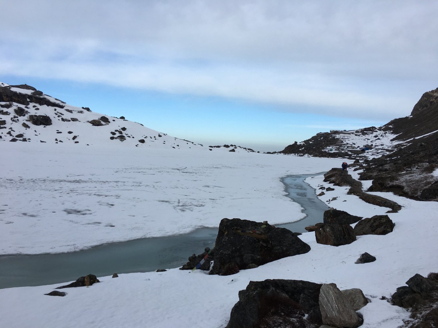
Lauribina La Pass is one of the highest points on the Gosaikunda to Helambu route in the Langtang region of Nepal. Standing at around 4,610 m (15,124 ft), the pass connects the sacred Gosaikunda lake basin with the trails leading into Helambu. The crossing involves a relatively short climb from Gosaikunda followed by a long and steep descent toward Phedi and Ghopte, making this one of the more demanding sections of the Gosaikunda Helambu Trek.
The pass is also important for trekkers planning a longer Langtang Trek itinerary. A route that combines Langtang Valley, Gosaikunda and Helambu can include Lauribina La as the high point between the Gosaikunda side and Helambu. However, a standard Langtang Trek usually refers to the Langtang Valley route and does not automatically include Lauribina La.
This guide explains the Lauribina La Pass route in detail, including altitude, distance, difficulty, trail conditions, accommodation, permits, weather, preparation and the practical points to consider before crossing from Gosaikunda toward Helambu.
Lauribina La Pass at a Glance
| Detail | Information |
|---|---|
| Pass | Lauribina La Pass |
| Elevation | Approx. 4,610 m / 15,124 ft |
| Region | Langtang and Helambu |
| Protected Area | Langtang National Park |
| Main route | Gosaikunda → Lauribina La → Phedi → Ghopte → Tharepati |
| Gosaikunda elevation | Approx. 4,380 m |
| Gosaikunda to Lauribina La | Approx. 3 km |
| Gosaikunda to Lauribina La walking time | About 2 to 2.5 hours |
| Gosaikunda to Ghopte | Approx. 11 km |
| Gosaikunda to Ghopte walking time | About 7 to 9 hours |
| Difficulty | Moderate to strenuous |
| Highest point | Lauribina La, approx. 4,610 m |
| Main challenge | Altitude, steep descent and long walking day |
| Best seasons | March to May and October to November |
| Accommodation | Teahouses and lodges along the route |
| Guide and TIMS | Required under current regulations for this route |
Where Is Lauribina La Pass?
Lauribina La Pass lies above Gosaikunda inside Langtang National Park, between the Gosaikunda lake basin and the Helambu side of the trekking route. The pass is reached after climbing from Gosaikunda through a rocky high-altitude landscape and then descending toward Phedi and Ghopte.
Gosaikunda itself sits at approximately 4,380 m, so trekkers are already at high altitude before beginning the pass crossing. The climb to Lauribina La is therefore not especially large in terms of elevation gain, but the thin air, cold conditions and exposed terrain make the morning section physically demanding.
From the top of the pass, the trail drops toward Phedi and continues through Ghopte before reaching Tharepati and the Helambu villages. This makes Lauribina La an important transition point between the high alpine landscape around Gosaikunda and the forested and settled trails of Helambu.
Lauribina La Pass and the Langtang Region
Lauribina La is part of the wider Langtang trekking region, but it should not be confused with the standard Langtang Valley Trek. The usual Langtang Trek follows the Langtang Valley toward Kyanjin Gompa, while the Gosaikunda route branches toward the sacred lakes and eventually reaches Lauribina La.
The connection becomes particularly useful on longer itineraries that combine Langtang Valley, Gosaikunda and Helambu. Trekkers can walk through Langtang Valley, continue toward Gosaikunda and then cross Lauribina La before descending into Helambu. This creates a much longer journey through different landscapes, villages and cultural areas than the standard Langtang Valley route.
For readers comparing trekking options, this distinction is useful. Our Langtang Trek follows the Langtang Valley route, while our Langtang Helambu Trekking connects Langtang with Gosaikunda and Helambu for trekkers who want to experience several parts of the region in one journey.
Gosaikunda to Helambu via Lauribina La Pass
The Gosaikunda to Helambu route is commonly divided into several sections because the crossing day is long. The trail first climbs from Gosaikunda to Lauribina La, then descends steeply to Phedi before continuing toward Ghopte. From Ghopte, trekkers continue toward Tharepati and then enter the wider Helambu trail network.
| Route section | Approx. distance | Walking time | Main feature |
|---|---|---|---|
| Gosaikunda → Lauribina La | 3 km | 2–2.5 hrs | Rocky high-altitude climb |
| Lauribina La → Phedi | 3.5 km | 2–2.5 hrs | Steep rocky descent |
| Phedi → Ghopte | 4.5 km | 2.5–3 hrs | Forest trail with ups and downs |
| Gosaikunda → Ghopte | Approx. 11 km | 7–9 hrs | Main pass-crossing day |
| Ghopte → Tharepati | Approx. 4 km | 2–2.5 hrs | Forest and gradual climb |
Distances and walking times vary with trail conditions, weather, pack weight and individual pace, so they should be treated as practical estimates rather than fixed measurements.
Gosaikunda to Lauribina La
The trail leaves the Gosaikunda area and climbs through rocky terrain toward the higher lakes and the ridge around Lauribina La. The climb is steady rather than extremely steep, but altitude becomes increasingly noticeable as you move above 4,400 m.
The early start is important because the route is exposed in places and weather can change quickly at this elevation. On a clear morning, the surrounding mountains and high-altitude lakes make this one of the most scenic sections of the Gosaikunda to Helambu trek.
The elevation gain from Gosaikunda to the pass is only around 230 m, but that figure can be misleading. At more than 4,000 m, even a moderate climb can feel considerably harder than the same climb at lower elevations.
Crossing Lauribina La Pass
Lauribina La reaches approximately 4,610 m, making it the highest point of this section of the route. Prayer flags and the open mountain landscape mark the high point, while the terrain around the pass is rocky and exposed.
The pass itself is not a technical climbing route. You do not normally need ropes or climbing equipment for the crossing. The main concerns are altitude, cold, wind, snow or ice when present, and the physical effort required for the long day that follows.
From our experience of planning high-altitude trekking routes, one of the most useful habits on this section is to keep the morning steady rather than trying to reach the pass quickly. A slower pace gives trekkers more time to manage their breathing and notice how they are responding to the altitude.
Trekkers should avoid spending unnecessary time at the top if the weather is deteriorating. A short rest to drink water, take photographs and enjoy the view is reasonable, but the descent should begin while conditions remain manageable.
Lauribina La to Phedi
The descent from Lauribina La toward Phedi is one of the most physically demanding parts of the entire crossing. The trail loses a substantial amount of elevation over rocky ground, and loose stones can make footing difficult.
This section can be particularly hard on the knees after the effort of reaching the pass. Trekking poles are useful here because they provide additional balance and reduce some of the strain on the knees during the descent.
Snow and ice can also change the character of this section during winter or after fresh snowfall. Conditions should be checked before setting out rather than relying only on the conditions experienced at Gosaikunda.
Phedi to Ghopte
After reaching Phedi, the trail continues through a mixture of rocky terrain and forest. The route is not simply downhill from this point, as there are several climbs and descents before reaching Ghopte.
Ghopte is an important overnight stop because completing the entire journey from Gosaikunda to a much lower Helambu settlement in one day would make an already long pass-crossing day unnecessarily demanding. Staying at Ghopte allows trekkers to recover before continuing toward Tharepati and the Helambu villages.
Ghopte to Tharepati and Helambu
The trail from Ghopte toward Tharepati enters a more forested environment and feels very different from the exposed landscape around Gosaikunda and Lauribina La. The elevation also begins to fluctuate less dramatically than during the pass crossing.
From Tharepati, the route continues through the Helambu region, with different itinerary options depending on the final destination. Trekkers may continue toward settlements such as Kutumsang or follow another Helambu route toward the Melamchi Valley.
This change in landscape is one of the main attractions of crossing Lauribina La. Within a relatively short period, the route moves from high alpine lakes and exposed rocky slopes into forests, villages and cultivated hillsides.
How Does Lauribina La Fit into Longer Itineraries?
Lauribina La can be included in several trekking itineraries through the Langtang, Gosaikunda and Helambu regions. The pass becomes the key high-altitude connection between Gosaikunda and Helambu, while longer itineraries allow trekkers to experience more of the Langtang Valley before reaching the pass.
| Itinerary | Typical Duration | Route |
|---|---|---|
| Gosaikunda Trek | 7 to 9 days | Dhunche → Thulo Syabru → Sing Gompa → Gosaikunda → Lauribina La → Ghopte → Tharepati → Helambu |
| Langtang Helambu Trekking | Longer combined itinerary | Langtang Valley → Kyanjin Gompa → Gosaikunda → Lauribina La → Ghopte → Tharepati → Helambu |
| Langtang Trek + Gosaikunda and Helambu | Extended itinerary | Syabrubesi → Langtang Valley → Kyanjin Gompa → Gosaikunda → Lauribina La → Ghopte → Tharepati → Helambu |
For trekkers who want to experience the Langtang Valley before crossing Lauribina La, our Langtang Trek can be combined with the Gosaikunda and Helambu section. This allows the journey to progress from the Langtang Valley and Kyanjin Gompa toward the higher Gosaikunda area before crossing Lauribina La and descending toward Helambu.
Our Langtang Helambu Trekking is another option for trekkers who want to connect these different parts of the region in one longer journey. The exact number of days and final Helambu route can be adjusted according to the chosen itinerary, available trekking time and acclimatization requirements.
For a shorter trip, the Gosaikunda to Helambu section can focus specifically on reaching Gosaikunda, crossing Lauribina La and continuing through Ghopte and Tharepati into Helambu. For a longer Langtang combination, the additional days in the Langtang Valley provide more time to experience Kyanjin Gompa and the surrounding high mountain landscape before continuing toward Gosaikunda.
Lauribina La Pass Altitude
Lauribina La stands at approximately 4,610 m (15,124 ft), while Gosaikunda is around 4,380 m. The difference between the two elevations is not large, but the pass should still be treated as a high-altitude crossing.
| Location | Approx. elevation |
|---|---|
| Gosaikunda | 4,380 m |
| Lauribina La Pass | 4,610 m |
| Phedi | Approx. 3,700 m |
| Ghopte | Approx. 3,400 m |
| Tharepati | Approx. 3,600–3,700 m |
Altitude becomes an important consideration because the route crosses above 4,500 m even though the total ascent from Gosaikunda is relatively small. Spending several nights at progressively higher elevations before reaching Gosaikunda is therefore useful preparation for the pass.
How Difficult Is Lauribina La Pass?
Lauribina La Pass is generally a moderate to strenuous trekking section rather than a technical climbing route. The difficulty comes from the combination of altitude, uneven terrain, a long walking day and the steep descent after the pass.
The Gosaikunda to Ghopte section can take around seven to nine hours depending on pace and trail conditions. The first part of the day is spent climbing toward the pass, while the later sections involve a long descent and additional ups and downs toward Ghopte.
Trekkers who are comfortable with long days of mountain walking and who have acclimatized properly can generally manage the crossing. It is less suitable for someone who has little experience with high-altitude trekking or who has not allowed enough time to adjust to the elevation.
Who Should Cross Lauribina La?
Lauribina La is suitable for trekkers who have reasonable fitness, previous experience with long mountain walks or adequate preparation for a high-altitude trekking day. The route does not normally require technical climbing skills, but trekkers should be comfortable walking for several hours over rocky and uneven terrain.
Anyone planning the crossing should also be prepared for changing mountain weather. A trekker who is comfortable at 3,000 m should not assume that the same pace will automatically work above 4,500 m. Altitude affects people differently, and the ability to slow down, rest and change plans when necessary is an important part of safe trekking.
Lauribina La Trail Conditions
The trail varies considerably along the route. Around Gosaikunda and the pass, the landscape is largely rocky and exposed, while the descent toward Phedi becomes steep and uneven. Further toward Ghopte and Tharepati, the route enters more forested terrain.
Loose stones and uneven steps are common, particularly on the descent from the pass. Trekking boots with good grip are useful because the trail can become slippery after rain, snow or freezing conditions.
In winter, snow and ice can cover sections of the trail. The exact amount depends on snowfall and current weather, so equipment requirements should be based on current conditions rather than a fixed seasonal assumption.
Lauribina La Pass Weather and Snow
Weather at Lauribina La can change quickly because the pass is above 4,600 m. Even when conditions are comfortable around lower settlements, the pass can be cold and windy.
Spring and autumn generally provide the most suitable conditions for trekking in the Langtang National Park area. Nepal Tourism Board identifies March to May and October to November as the main trekking seasons, while June to September brings monsoon conditions and December to February brings winter snow at higher elevations.
Winter does not automatically mean that Lauribina La cannot be crossed. The practical issue is the amount of snow and ice on the trail, visibility, temperature and the condition of the descent. After significant snowfall, the pass can become substantially more difficult and should only be attempted after checking current local conditions.
Best Time to Cross Lauribina La Pass
The best periods for a Lauribina La Pass trek are generally spring and autumn. March to May brings improving weather and spring vegetation, while October and November are known for clearer mountain views and generally stable trekking conditions.
Early spring can still bring snow around the pass, especially after winter weather. Similarly, late autumn becomes progressively colder as winter approaches, so warm clothing remains essential even during the main trekking season.
The monsoon months from June to September are less predictable. Rain, cloud, wet trails and reduced visibility can make the route more difficult, while conditions around the high pass can change quickly. Nepal Tourism Board identifies June to September as the monsoon period in the Langtang region.
Settlements and Teahouses Along the Route
Accommodation is available along the Gosaikunda to Helambu route, but the high-pass section has fewer facilities than the lower parts of the trek. Gosaikunda has teahouses and lodges, while Phedi and Ghopte provide basic stopping and accommodation options depending on the season and current operating conditions.
The facilities become more varied as you continue toward Tharepati and the Helambu settlements. Rooms are generally basic, and facilities at higher elevations can be limited compared with hotels in Kathmandu or Pokhara. Because this is a high-altitude route, it is sensible to carry enough water and snacks for the pass-crossing section. Food and accommodation availability can also change according to season, weather and the number of trekkers on the trail.
Permits for Lauribina La Pass
The Lauribina La route falls within Langtang National Park, so trekkers need the required Langtang National Park entry permit. The current Nepal Tourism Board fee is NPR 3,000 for foreign visitors and NPR 1,500 for SAARC nationals.
A TIMS card is also required under the current trekking regulations. Nepal Tourism Board specifically lists Helambu Trek, Gosaikunda Trek and Langtang Trek among the routes requiring a licensed trekking guide and agency-issued TIMS card. The current TIMS charge is NPR 2,000 for non-SAARC trekkers and NPR 1,000 for SAARC nationals.
Permit requirements and fees can change, so the current regulations should be confirmed before departure. For an organized trek, the trekking agency can arrange the required documentation as part of the preparation.
How to Prepare for Lauribina La Pass
Preparation should focus on endurance, uphill walking and the ability to walk for a long period at altitude. Regular hiking before the trek is useful, particularly on trails with sustained climbs and descents.
The most important preparation is not simply physical strength. Your itinerary should allow enough time to acclimatize before reaching Gosaikunda. Trying to rush the route and reach 4,610 m without adequate adjustment to altitude increases the difficulty of the crossing.
A steady pace is generally more useful than trying to walk quickly. On the morning of the pass crossing, starting early gives you more time to deal with slow progress, changing weather or longer rest periods.
What to Pack for Lauribina La
Your packing list should reflect the altitude and the long pass-crossing day. Warm layers, waterproof protection, good trekking boots and sun protection are important throughout the season. For winter or snowy conditions, additional traction equipment may be necessary depending on the current trail conditions. Trekking poles are particularly useful for the steep descent from Lauribina La toward Phedi.
Essential items include:
- Good trekking boots with reliable grip
- Trekking poles
- Warm base and insulating layers
- Waterproof and windproof outer layer
- Gloves and warm hat
- Sunglasses and sunscreen
- Headlamp
- Water bottle or hydration system
- Water purification method
- High-energy snacks
- Personal medication and basic first-aid supplies
- Sleeping bag suitable for the season
- Microspikes or similar traction equipment when snow and ice are present
Altitude and Safety on Lauribina La
Altitude is one of the main safety concerns on the Lauribina La Pass route. Gosaikunda already sits at approximately 4,380 m, and the trail climbs above 4,600 m the following day. Symptoms such as headache, nausea, dizziness, unusual fatigue or loss of appetite should be taken seriously.
The correct response to worsening altitude symptoms is not to push harder to reach the pass. If symptoms become severe or continue to worsen, descending to a lower elevation is the safer option.
Cold exposure is another concern around the pass. Wind, snow and wet clothing can quickly reduce body temperature, particularly when trekkers stop for long periods. Keep warm layers accessible rather than buried at the bottom of your backpack.
Sun protection is also important at high altitude. Strong sunlight reflected from snow and rock can cause significant glare, so sunglasses and sunscreen should be used even on cold days.
Travel insurance that covers high-altitude trekking and emergency helicopter evacuation is strongly recommended. If an emergency occurs in a remote section of the route, evacuation can be expensive without appropriate insurance coverage.
How Many Days Do You Need for a Lauribina La Trek?
The number of days depends on where you start and finish. A dedicated Gosaikunda to Helambu itinerary can generally be planned over several days, while a longer Langtang Gosaikunda Helambu Trek takes considerably more time.
The important point is to avoid treating Lauribina La as an isolated one-day challenge. The pass is part of a longer high-altitude route, and the days leading up to the crossing are important for acclimatization.
A typical sequence might include walking toward Gosaikunda, spending the night around the lake, crossing Lauribina La the following morning, staying around Ghopte, and then continuing toward Tharepati and Helambu.
Is Lauribina La Part of the Helambu Trek?
Lauribina La can be included in a Helambu trekking itinerary, but it is not the same thing as the Helambu Trek. The pass is the high-altitude connection between the Gosaikunda side and the Helambu trail network.
A trek beginning in the Gosaikunda area and continuing over Lauribina La can then descend toward Ghopte, Tharepati and other Helambu settlements. Other Helambu itineraries start from lower trailheads and do not cross Lauribina La.
This distinction matters when comparing trekking itineraries. If you are considering a Helambu Trek, check the actual route before assuming that it includes the 4,610 m pass.
Is Lauribina La Part of the Langtang Trek?
Lauribina La belongs to the wider Langtang trekking region, but it is not automatically part of the standard Langtang Valley Trek. The classic Langtang route generally follows the Langtang Valley toward Kyanjin Gompa, while Lauribina La is reached through the Gosaikunda side of the region.
The pass can be included in a longer Langtang Gosaikunda Helambu itinerary. Such a route connects several trekking areas and provides a much broader experience of the Langtang region than a standard Langtang Valley itinerary.
This is why it is useful to check the exact itinerary rather than choosing a trek based only on the general name of the region.
Current Trail and Road Conditions
For 2026, access conditions in the Langtang and Gosaikunda area should be checked shortly before departure. Recent flooding has affected parts of the road network used to reach the region, although the trekking destinations themselves can remain accessible. Our 2026 Nepal trekking safety update notes that the Langtang/Kyanjin Valley and Gosaikunda destinations were reported as safe in the cited TAAN update, while the Trishuli–Betrawati access route was affected.
This is particularly important when planning transportation to the trailhead. Road conditions can change during the monsoon and recovery period, so your trekking agency should confirm the latest road situation and adjust transportation arrangements if necessary.
Route Map
The main Lauribina La Pass route from Gosaikunda toward Helambu follows:
Gosaikunda → Lauribina La → Phedi → Ghopte → Tharepati → Helambu
A route map is particularly useful for this trek because the elevation profile changes significantly within a single day. The map should clearly show Gosaikunda, Lauribina La, Phedi, Ghopte, Tharepati and the main Helambu settlements.
For an NHT article, an original route map showing these points would also help readers understand how the pass connects the Gosaikunda and Helambu sections of the trek.
Frequently Asked Questions About Lauribina La Pass
What is the altitude of Lauribina La Pass?
Lauribina La Pass is approximately 4,610 m (15,124 ft) above sea level. It is the highest point of the Gosaikunda to Helambu crossing.
How long does it take to cross Lauribina La?
The crossing from Gosaikunda to Ghopte generally takes around seven to nine hours, including the climb to the pass and the long descent toward Ghopte. Walking times vary according to pace, weather, trail conditions and acclimatization.
Is Lauribina La Pass difficult?
Lauribina La is generally considered a moderate to strenuous trekking section. The route is not normally technical, but the altitude, rocky trail, steep descent and long walking day make it physically demanding.
Can beginners cross Lauribina La?
Beginners can potentially cross Lauribina La if they are physically prepared, follow an appropriate itinerary and acclimatize properly. However, it should not be treated like a low-altitude day hike. Previous hiking experience is useful, especially because the route involves a long day above 4,000 m.
Do I need a guide for Lauribina La?
Yes. Under Nepal's current trekking regulations, the Gosaikunda and Helambu routes require a licensed trekking guide and agency-issued TIMS card. Nepal Tourism Board lists both Gosaikunda Trek and Helambu Trek among the routes covered by the mandatory guide and TIMS provision.
Is Lauribina La covered in snow?
Snow is possible, particularly during winter and following fresh snowfall. The amount of snow varies from year to year and according to current weather conditions. Trekkers should check local trail conditions before crossing and carry appropriate traction equipment when necessary.
What is the best month for Lauribina La Pass?
March to May and October to November are generally the best periods for trekking in the Langtang region. Autumn often provides clear mountain views, while spring brings warmer conditions and seasonal vegetation.
Can I do Lauribina La without going to Gosaikunda?
The pass is most commonly crossed as part of a route connecting Gosaikunda with Helambu. Other approaches are possible, but the Gosaikunda to Helambu route is the most relevant itinerary for trekkers specifically looking to cross Lauribina La.
How high is Gosaikunda compared with Lauribina La?
Gosaikunda is approximately 4,380 m, while Lauribina La reaches around 4,610 m. The climb from the lake to the pass is therefore only around 230 m, although the altitude makes the climb feel harder than the elevation gain suggests.
Is Lauribina La part of the Langtang Gosaikunda Trek?
Yes, it can be. A combined Langtang Gosaikunda Helambu itinerary can travel from Langtang Valley to Gosaikunda and then cross Lauribina La toward Helambu. A standard Langtang Valley Trek, however, does not necessarily include the pass.
Final Thoughts
Lauribina La Pass is a demanding but rewarding section of the Gosaikunda to Helambu route. The actual climb from Gosaikunda to 4,610 m is relatively short, but the combination of altitude, rocky terrain and the long descent toward Phedi makes the crossing a serious trekking day.
Good acclimatization, an early start, appropriate clothing and a steady pace make a significant difference. It is also important to check current weather and trail conditions, particularly when planning the crossing during winter or after fresh snowfall.
For trekkers looking to connect Gosaikunda with Helambu, Lauribina La provides the high-altitude link between the two areas. When combined with the Langtang Valley, it can also become part of a longer Langtang Gosaikunda Helambu journey through some of the most varied landscapes in the region.
If you are planning to cross Lauribina La as part of a longer Langtang, Gosaikunda or Helambu trek, the itinerary should be planned around acclimatization, realistic walking times and current trail conditions. Contact Nepal Himalayas Trekking to discuss your route, current conditions and trekking arrangements with our local team. You can also explore the Nepal Himalayas Trekking homepage for our Langtang, Gosaikunda, Helambu and other Nepal trekking packages.








Add Your Comment